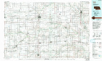
1985 Map of York
USGS Topo · Published 1985About this map
Burlington Northern tracks and major highways like 80 and 81 define the transport corridors of this Nebraska landscape, linking agricultural hubs from Aurora to Seward. The map reveals a high concentration of institutional landmarks, including Concordia Teachers College, the State Reformatory for Women, and specialized educational facilities like the State Girls Training School. These sites, alongside regional airfields such as Fairmont State Airport, illustrate the area's development as a center for state services and education during the mid-1980s.
Find a feature on this map
90 named features on this map. Tap any name to fly to it.
Don’t see what you’re looking for? This feature index may not catch every label — zoom into the map to look around manually.
Map Details
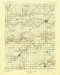
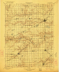
Editions of this 1985 York Map
2 editions found