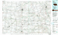
1985 Map of York
USGS Topo · Published 1994About this map
The agricultural plains of southeastern Nebraska are defined here by a dense grid of section lines and the winding course of the Big Blue River and its numerous forks. This mid-1980s landscape shows the critical intersection of the Burlington Northern Railroad and the Union Pacific Railroad, which historically dictated the growth of towns like York, Seward, and Geneva. The area is notably punctuated by specialized institutions and conservation efforts, including the State Girls Training School near Geneva and several waterfowl production areas such as Rolland Lagoon National Waterfowl Production Area. The flat terrain, while largely partitioned for farming, preserves natural depressions and wetlands like Bergeson Basin and Staplehurst Lake. Transport corridors like Interstate 80 cut horizontally across the sheet, linking the major hubs of Aurora and York with the state's eastern population centers.
Find a feature on this map
92 named features on this map. Tap any name to fly to it.
Don’t see what you’re looking for? This feature index may not catch every label — zoom into the map to look around manually.
Map Details
Editions of this 1985 York Map
2 editions found
Other maps of this area

1896 · Stromsburg
USGS Topo · 1:125,000

1897 · Lincoln
USGS Topo · 1:125,000

1898 · York
USGS Topo · 1:125,000

1898 · Superior
USGS Topo · 1:125,000

1898 · Hebron
USGS Topo · 1:125,000

1898 · Grand Island
USGS Topo · 1:125,000

1899 · Wahoo
USGS Topo · 1:125,000

1899 · David City
USGS Topo · 1:125,000

1899 · St. Paul
USGS Topo · 1:125,000

1899 · York
USGS Topo · 1:125,000