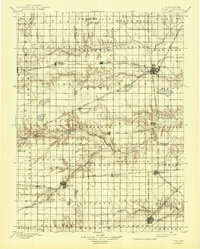
1898 Map of York
USGS Topo · Published 1943About this map
The South Platte Valley region of Nebraska reveals a landscape deeply influenced by late 19th-century railroad expansion and the systematic township and range surveying of the era. The city of York serves as a major hub for multiple rail lines, including the Burlington and Missouri River R. R. and the Kansas City and Omaha R. R., illustrating the connectivity that drove local commerce. To the south, Geneva and Sutton appear as established agricultural centers along the B. & M. R. R. R. Main Line, while smaller settlements like Lushton, Charleston, and Henderson are positioned near the wandering courses of Beaver Creek and the Big Blue River. This topography, surveyed by Henry Gannett and his team, shows the transition from the prairie floor into the complex drainage networks of Lincoln Creek and the West Fork Big Blue River.
Find a feature on this map
68 named features on this map. Tap any name to fly to it.
Don’t see what you’re looking for? This feature index may not catch every label — zoom into the map to look around manually.
Map Details
Editions of this 1898 York Map
4 editions found
Other maps of this area

1896 · Stromsburg
USGS Topo · 1:125,000

1898 · York
USGS Topo · 1:125,000

1898 · Superior
USGS Topo · 1:125,000

1898 · Hebron
USGS Topo · 1:125,000

1898 · Grand Island
USGS Topo · 1:125,000

1899 · David City
USGS Topo · 1:125,000

1899 · St. Paul
USGS Topo · 1:125,000

1899 · York
USGS Topo · 1:125,000

1934 · Utica
USGS Topo · 1:62,500

1937 · Utica
USGS Topo · 1:62,500