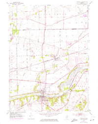
1953 Map of Yorkville
USGS Topo · Published 1974About this map
The Fox River carves a deep valley through Kendall County in this mid-century survey, anchoring the development of Yorkville and Bristol. The river's path is paralleled by the Burlington Northern railroad, a corridor that defined the local economy of the 1950s. Purple revisions from the early 1970s illustrate the expansion of these towns, showing how suburban growth began to push into the surrounding agricultural landscape. Away from the river, the map preserves the locations of several rural landmarks that speak to the area's earlier settlement. Genealogists can locate Jericho Cem, Oak Grove Cem, and Elmwood Cem, while the Faxon Sch remains marked along the western edge of the quadrangle. Significant watercourses like Big Rock Creek and Blackberry Creek feed into the Fox, shaping the drainage patterns and historical property lines of the Little Rock and Bristol townships.
Find a feature on this map
22 named features on this map. Tap any name to fly to it.
Don’t see what you’re looking for? This feature index may not catch every label — zoom into the map to look around manually.
Map Details
Editions of this 1953 Yorkville Map
3 editions found
Other maps of this area

1925 · Yorkville
USGS Topo · 1:62,500

1932 · Geneva
USGS Topo · 1:62,500

1937 · Sycamore
USGS Topo · 1:62,500

1948 · Geneva
USGS Topo · 1:62,500

1948 · Sandwich
USGS Topo · 1:62,500

1950 · Sandwich
USGS Topo · 1:62,500

1950 · Aurora North
USGS Topo · 1:24,000

1953 · Plattville
USGS Topo · 1:24,000

1953 · Yorkville
USGS Topo · 1:24,000

1953 · Yorkville SE
USGS Topo · 1:24,000