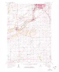
1954 Map of Yorkville
USGS Topo · Published 1959About this map
The Fox River corridor serves as the primary artery of development on this mid-century survey, linking the industrial expansion of Aurora and Montgomery to the smaller riverside communities of Oswego and Yorkville. The landscape reveals a post-war shift as residential clusters like South Park appear near Mastodon Lake, while the surrounding townships maintain a dense network of one-room schools and rural churches. Genealogists can identify numerous family-named landmarks and institutions, including the Plecher Sch, McCauley Sch, and Jones Sch, many of which were the social hubs for the agricultural hinterlands of Na-Au-Say and Big Grove. The presence of the Chicago Burlington and Quincy railroad remains central to the region's connectivity, passing through Bristol (PO and Sta) and supporting local commerce before the era of major interstate highway dominance.
Find a feature on this map
67 named features on this map. Tap any name to fly to it.
Don’t see what you’re looking for? This feature index may not catch every label — zoom into the map to look around manually.
Map Details
Editions of this 1954 Yorkville Map
2 editions found
Other maps of this area

1892 · Morris
USGS Topo · 1:62,500

1892 · Marseilles
USGS Topo · 1:62,500

1892 · Joliet
USGS Topo · 1:62,500

1892 · Wilmington
USGS Topo · 1:62,500

1908 · Wheaton
USGS Topo · 1:62,500

1916 · Marseilles
USGS Topo · 1:62,500

1918 · Wilmington
USGS Topo · 1:62,500

1918 · Morris
USGS Topo · 1:62,500

1923 · Joliet
USGS Topo · 1:62,500

1925 · Yorkville
USGS Topo · 1:62,500