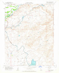
1962 Map of Yosemite Lake
USGS Topo · Published 1963About this map
Yosemite Lake and the Merced River define this central California landscape at the start of the 1960s, where an extensive network of water management features like the Main Canal and Snelling Canal support the valley floor. The map highlights the transition from the river's path down into the irrigation-dependent plains, marked by the presence of tailings near the riverbanks that suggest past dredging or mining activity. Transportation and recreational growth are evident through the Old Railroad Grade and the Merced Golf Club near the Hornitos Road. Local history is captured in the small settlement of Youd and several family-named landmarks like Parkinson Road and Parkinson Creek, providing a detailed view of Merced County's hydraulic and agricultural infrastructure before further modern development.
Find a feature on this map
24 named features on this map. Tap any name to fly to it.
Don’t see what you’re looking for? This feature index may not catch every label — zoom into the map to look around manually.
Map Details
Editions of this 1962 Yosemite Lake Map
4 editions found
Other maps of this area

1893 · Sonora
USGS Topo · 1:125,000

1896 · Sonora
USGS Topo · 1:125,000

1897 · Sonora
USGS Topo · 1:125,000

1898 · Sonora
USGS Topo · 1:125,000

1913 · Dickenson
USGS Topo · 1:31,680

1914 · Merced
USGS Topo · 1:31,680

1916 · Three Tree Flat
USGS Topo · 1:31,680

1916 · Hopeton
USGS Topo · 1:31,680

1916 · Merced Falls
USGS Topo · 1:24,000

1917 · Winton
USGS Topo · 1:31,680