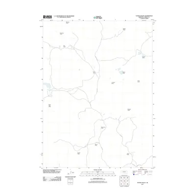
2011 Map of Young Valley
USGS Topo · Published 2011About this map
Young Valley defines the heart of this Garden County landscape, where the topography is primarily characterized by a series of distinct valleys named for local families and early settlers. This 2011 survey by the U.S. Geological Survey details a rural Nebraska environment dominated by these named depressions, including Warneke Valley and Sophia Valley in the north, and Keenan Valley and Robb Valley to the south. The road network is sparse, with routes like Bingham Rd and Road 199 providing the primary access through the terrain. The prevalence of named features such as Black Steer Valley and Lost Bull Valley suggests a history tied closely to ranching and land use, where specific topographical landmarks were essential for navigation and property identification in an open landscape.
Find a feature on this map
21 named features on this map. Tap any name to fly to it.
Don’t see what you’re looking for? This feature index may not catch every label — zoom into the map to look around manually.
Map Details
Editions of this 2011 Young Valley Map
This is the sole edition of this map. No revisions or reprints were ever made.
Other maps of this area

1949 · Mumper
USGS Topo · 1:62,500

1949 · Rackett
USGS Topo · 1:62,500

1950 · Crescent Lake
USGS Topo · 1:62,500

1950 · Longfellow Lake
USGS Topo · 1:62,500

1951 · Rackett
USGS Topo · 1:62,500

1954 · Scottsbluff
USGS Topo · 1:250,000

1958 · Scottsbluff
USGS Topo · 1:250,000

1985 · Crescent Lake
USGS Topo · 1:100,000
1986 · McCarty Lake
USGS Topo · 1:24,000
1986 · Hessey Lake
USGS Topo · 1:24,000