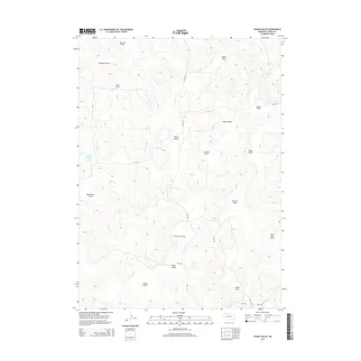
2014 Map of Young Valley
USGS Topo · Published 2014About this map
Young Valley and the surrounding pocketed depressions of Garden County define this corner of the Nebraska Sandhills. The landscape is characterized by a dense network of named lowlands, including Warneke Valley, Schmoker Valley, and Sophia Valley, which reveal the historical importance of specific grazing lands and family ranching sites. While much of the terrain is arid, Britton Lake provides a notable water source in the western section of the map.
Find a feature on this map
25 named features on this map. Tap any name to fly to it.
Don’t see what you’re looking for? This feature index may not catch every label — zoom into the map to look around manually.
Map Details
Editions of this 2014 Young Valley Map
This is the sole edition of this map. No revisions or reprints were ever made.
Other maps of this area

1949 · Mumper
USGS Topo · 1:62,500

1949 · Rackett
USGS Topo · 1:62,500

1950 · Crescent Lake
USGS Topo · 1:62,500

1950 · Longfellow Lake
USGS Topo · 1:62,500

1951 · Rackett
USGS Topo · 1:62,500

1954 · Scottsbluff
USGS Topo · 1:250,000

1958 · Scottsbluff
USGS Topo · 1:250,000

1985 · Crescent Lake
USGS Topo · 1:100,000
1986 · McCarty Lake
USGS Topo · 1:24,000
1986 · Hessey Lake
USGS Topo · 1:24,000