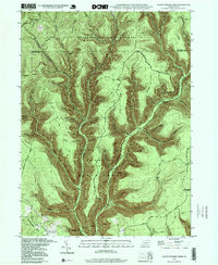
1994 Map of Young Womans Creek
USGS Topo · Published 1999About this map
Young Womans Creek carves a deep path through the north-central Pennsylvania wilderness, serving as the primary drainage for a landscape defined by the rugged interface of the Susquehannock State Forest and Sproul State Forest. This 1994 update reveals a territory almost entirely dedicated to conservation and forestry, where the boundary between Stewardson and Chapman townships follows the high ridges. The map highlights the intricate network of watercourses that feed the creek, including the Left Branch Young Womans Creek and various family-named features like Lecox Run and French Joe Run.
Find a feature on this map
40 named features on this map. Tap any name to fly to it.
Don’t see what you’re looking for? This feature index may not catch every label — zoom into the map to look around manually.
Map Details
Editions of this 1994 Young Womans Creek Map
This is the sole edition of this map. No revisions or reprints were ever made.
Other maps of this area

1943 · Hyner
USGS Topo · 1:62,500

1946 · Young Womans Creek
USGS Topo · 1:24,000

1946 · Renovo East
USGS Topo · 1:62,500

1946 · Renovo West
USGS Topo · 1:62,500

1946 · Tamarack
USGS Topo · 1:24,000

1946 · Slate Run
USGS Topo · 1:24,000

1946 · Renovo East
USGS Topo · 1:24,000

1946 · Renovo West
USGS Topo · 1:24,000

1946 · Glen Union
USGS Topo · 1:24,000

1947 · Conrad
USGS Topo · 1:62,500