
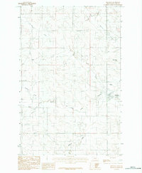
1983 Map of Youngquist Mine
USGS Topo · Published 1983About this map
Youngquist Mine is the industrial centerpiece of this sparsely populated McCone County landscape, situated amidst a complex network of dry coulees and drainages. The topography is defined by the carved paths of Horse Creek in the north and central regions, while Antelope Creek cuts through the southwestern corner. These intermittent watercourses and named features like Denwoody and Lone Tree Creek illustrate the water-scarce environment of eastern Montana in the early 1980s. A provisional survey produced by the U.S. Geological Survey, this map records the specific elevation points and section lines crucial for land ownership research and mineral history in the northern plains. The lack of established towns or roads emphasizes the isolation of the mine site during this period of resource extraction.
Find a feature on this map
5 named features on this map. Tap any name to fly to it.
Don’t see what you’re looking for? This feature index may not catch every label — zoom into the map to look around manually.
Map Details
Editions of this 1983 Youngquist Mine Map
This is the sole edition of this map. No revisions or reprints were ever made.
Other maps of this area

1954 · Glendive
USGS Topo · 1:250,000

1957 · Glendive
USGS Topo · 1:250,000

1958 · Glendive
USGS Topo · 1:250,000

1982 · Circle
USGS Topo · 1:100,000

1983 · Brockway NE
USGS Topo · 1:24,000

1983 · Haynie Reservoir
USGS Topo · 1:24,000

1983 · North Fork Horse Creek
USGS Topo · 1:24,000

1983 · Quick Reservoir
USGS Topo · 1:24,000

1983 · Circle
USGS Topo · 1:24,000
1983 · Brockway
USGS Topo · 1:24,000