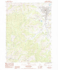
1984 Map of Yreka
USGS Topo · Published 1984About this map
The county seat of Yreka dominates the northeastern corner of this study, positioned where the high country of the Klamath National Forest meets the open Shasta Valley. This 1980s landscape is a complex mix of civic development and resource extraction, evidenced by the proximity of Evergreen Cemetery and Discovery Park to the industrial infrastructure of the Yreka Western RR. Outside the urban center, the terrain is defined by a dense network of gulches and ridges, including the prominent Montana Peak and Bally Mountain. Historical land use is visible in features like the Scorpion Mine and the Western Canal, which reflect the region's long-standing reliance on mining and water management. To the west, the Greenhorn Reservoir and various watercourses like Greenhorn Creek and Humbug Gulch illustrate how the watershed was controlled to support the growing settlement and its surrounding industries.
Find a feature on this map
48 named features on this map. Tap any name to fly to it.
Don’t see what you’re looking for? This feature index may not catch every label — zoom into the map to look around manually.
Map Details
Editions of this 1984 Yreka Map
This is the sole edition of this map. No revisions or reprints were ever made.
Other maps of this area

1886 · Shasta
USGS Topo · 1:250,000

1894 · Shasta
USGS Topo · 1:250,000

1922 · Shasta Valley Sheet No 3
USGS Topo · 1:24,000

1922 · Shasta Valley Sheet No 3 S
USGS Topo · 1:24,000

1932 · Yreka
USGS Topo · 1:96,000

1939 · Yreka
USGS Topo · 1:125,000

1948 · Weed
USGS Topo · 1:250,000

1950 · Weed
USGS Topo · 1:250,000

1954 · Yreka
USGS Topo · 1:62,500

1955 · Condrey Mtn
USGS Topo · 1:62,500