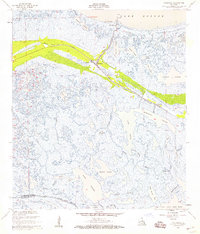
1957 Map of Yscloskey
USGS Topo · Published 1959About this map
Old Fort Beauregard stands as a silent sentinel on the southern shore of Lake Borgne, marking a point where the firm ground of the Gulf coast gives way to the intricate marshlands of St. Bernard Parish. This late-1950s survey documents a landscape defined by the serpentine curves of Bayou La Loutre and the settlements that clung to its banks, including Yscloskey, Alluvial City, and Hopedale. These communities served as critical outposts for the local fishing and trapping economies, situated along the Spoil Bank and surrounded by a vast network of lagoons like Portman Lagoon and Hopedale Lagoon. To the south, the map reveals the boundary with Plaquemines Parish at Bayou Terre Aux Boeufs, a region dominated by tidal waters such as Lake Amedee and Lake Jean Louis Robin. The abundance of named waterways, from Grosbec Bayou to Juanita Bayou, illustrates the deep local knowledge required to navigate this labyrinthine coastal environment before modern channelization altered the flow of the wetlands.
Find a feature on this map
41 named features on this map. Tap any name to fly to it.
Don’t see what you’re looking for? This feature index may not catch every label — zoom into the map to look around manually.
Map Details
Editions of this 1957 Yscloskey Map
2 editions found
Other maps of this area

1891 · Pointe a La Hache
USGS Topo · 1:62,500

1892 · St. Bernard
USGS Topo · 1:62,500

1892 · Pointe a La Hache
USGS Topo · 1:62,500

1893 · Shell Beach
USGS Topo · 1:62,500

1893 · Dime
USGS Topo · 1:62,500

1935 · Delacroix
USGS Topo · 1:31,680

1935 · Lake Calebasse
USGS Topo · 1:31,680

1935 · Lake Batola
USGS Topo · 1:31,680

1939 · Shell Beach
USGS Topo · 1:62,500

1939 · Pointe a La Hache
USGS Topo · 1:62,500