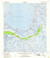
1957 Map of Yscloskey
USGS Topo · Published 1960About this map
Shell Beach and the neighboring settlements of Yscloskey and Alluvial City serve as the primary human outposts in this intricate landscape of marsh, lagoons, and bayous on the southern shore of Lake Borgne. The presence of Old Fort Beauregard near the coast hints at the strategic military importance of these waterways during earlier centuries. The map details a complex hydrologic network where Bayou Terre Aux Boeufs snakes through the wetlands toward Lake Amedee and Lake Jean Louis Robin, reflecting a delicate environment shaped by tidal influence and siltation.
Find a feature on this map
80 named features on this map. Tap any name to fly to it.
Don’t see what you’re looking for? This feature index may not catch every label — zoom into the map to look around manually.
Map Details
Editions of this 1957 Yscloskey Map
3 editions found
Other maps of this area

1891 · Pointe a La Hache
USGS Topo · 1:62,500

1892 · Chef Menteur
USGS Topo · 1:62,500

1892 · St. Bernard
USGS Topo · 1:62,500

1892 · Pointe a La Hache
USGS Topo · 1:62,500

1893 · Rigolets
USGS Topo · 1:62,500

1893 · La Fortuna
USGS Topo · 1:62,500

1893 · Shell Beach
USGS Topo · 1:62,500

1893 · Toulme
USGS Topo · 1:62,500

1893 · Dime
USGS Topo · 1:62,500

1895 · Bodreau
USGS Topo · 1:62,500