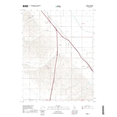
2018 Map of Zamora
USGS Topo · Published 2018About this map
Zamora anchors this agricultural corridor of Yolo County, situated where the flat Sacramento Valley floor begins to rise into the undulating terrain of the Dunnigan Hills. The landscape is defined by its complex water management and drainage systems, including the massive Colusa Basin Drainage Canal and the Tehama Colusa Canal, which slice across the valley to support the region's productive farmlands. In the west, the topography transitions from the alluvial plains of Bird Valley and Oat Valley into the more varied elevations of Hungry Hollow. This 2018 survey captures the intricate network of county roads, such as Co RD 99w and Eucalyptus Rd, that link the various agricultural holdings and creek beds. Seasonal drainages like Zamora Creek, Bird Creek, and Willow Spring Creek meander through the hills, illustrating the natural watershed patterns that predate the modern canal infrastructure.
Find a feature on this map
57 named features on this map. Tap any name to fly to it.
Don’t see what you’re looking for? This feature index may not catch every label — zoom into the map to look around manually.
Map Details
Editions of this 2018 Zamora Map
This is the sole edition of this map. No revisions or reprints were ever made.
Other maps of this area

1905 · Harrington
USGS Topo · 1:24,000

1905 · Esparto
USGS Topo · 1:24,000

1907 · Dunnigan
USGS Topo · 1:62,500

1907 · Woodland
USGS Topo · 1:62,500

1915 · Yolo
USGS Topo · 1:31,680

1915 · Ronda
USGS Topo · 1:31,680
1915 · Kirkville
USGS Topo · 1:31,680

1916 · Jacobs Corner
USGS Topo · 1:31,680

1916 · Harrington
USGS Topo · 1:31,680

1916 · Hershey
USGS Topo · 1:31,680