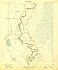
1915 Map of Kirkville
USGS Topo · Published 1915About this map
Sacramento River currents dominate this 1905 survey, winding through a complex series of tight oxbows and landings at the intersection of Sutter, Colusa, and Yolo counties. The landscape is defined by the massive Sutter Basin to the east and a hydraulic network of sloughs and lakes, including Mystic Lake and Horseshoe Lake. Settlement is concentrated at small river outposts like Kirkville and Cranmore, which served as vital points for commerce and transport before modern flood control reshaped the valley floor.
Find a feature on this map
30 named features on this map. Tap any name to fly to it.
Don’t see what you’re looking for? This feature index may not catch every label — zoom into the map to look around manually.
Map Details
Editions of this 1915 Kirkville Map
This is the sole edition of this map. No revisions or reprints were ever made.
Other maps of this area

1888 · Marysville
USGS Topo · 1:125,000

1891 · Marysville
USGS Topo · 1:125,000

1894 · Marysville
USGS Topo · 1:125,000

1895 · Marysville
USGS Topo · 1:125,000

1907 · Dunnigan
USGS Topo · 1:62,500

1910 · Knights Landing
USGS Topo · 1:31,680

1910 · Marcuse
USGS Topo · 1:31,680

1911 · Grimes
USGS Topo · 1:31,680

1911 · Gilsizer Slough
USGS Topo · 1:31,680
1912 · Tisdale Weir
USGS Topo · 1:31,680