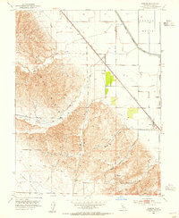
1953 Map of Zamora
USGS Topo · Published 1955About this map
The Dunnigan Hills dominate the western portion of this mid-century landscape, characterized by a series of north-south ridges that give way to the agricultural flatlands of the Sacramento Valley. The settlement of Zamora sits at the intersection of local roads and the Southern Pacific railroad line, serving as a hub for the surrounding ranching and farming operations. The map highlights the early energy infrastructure of the region, specifically the Dunnigan Gas Field, where several Gas Wells are marked across the undulating terrain.
Find a feature on this map
17 named features on this map. Tap any name to fly to it.
Don’t see what you’re looking for? This feature index may not catch every label — zoom into the map to look around manually.
Map Details
Editions of this 1953 Zamora Map
3 editions found
Other maps of this area

1905 · Harrington
USGS Topo · 1:24,000

1905 · Esparto
USGS Topo · 1:24,000

1907 · Dunnigan
USGS Topo · 1:62,500

1907 · Woodland
USGS Topo · 1:62,500

1915 · Yolo
USGS Topo · 1:31,680

1915 · Ronda
USGS Topo · 1:31,680
1915 · Kirkville
USGS Topo · 1:31,680

1916 · Jacobs Corner
USGS Topo · 1:31,680

1916 · Harrington
USGS Topo · 1:31,680

1916 · Hershey
USGS Topo · 1:31,680