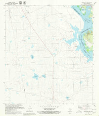
1979 Map of Zapata NW
USGS Topo · Published 1979About this map
Rio Grande Rio Bravo flows along the international boundary between the United States and Mexico, marking a landscape defined by the expansive Presa Falcon Reservoir. This late-1970s survey captures the riparian environment of Zapata County as it transitions from the river's path into the inundated reaches of the reservoir. Scattered ranching settlements and small locales such as El Ramireno and La Esperanza dot the brushy terrain, while the Old Ramireno Cem remains a significant marker of early regional history near the water's edge. The presence of several Gasoducto lines indicates the importance of energy infrastructure in this border region, crossing a landscape where traditional place names like Los Corrales and San Rafael persist alongside the modern management of the Rio Grande. Navigation buoys, including Buoy 33 and Buoy 26, delineate the jurisdictional waters near Jara China, reflecting the dual-national oversight of this hydrological system.
Find a feature on this map
37 named features on this map. Tap any name to fly to it.
Don’t see what you’re looking for? This feature index may not catch every label — zoom into the map to look around manually.
Map Details
Editions of this 1979 Zapata NW Map
This is the sole edition of this map. No revisions or reprints were ever made.
Other maps of this area

1942 · San Ygnacio
USGS Topo · 1:62,500

1949 · Mc Allen
USGS Topo · 1:250,000

1954 · McAllen
USGS Topo · 1:250,000

1956 · Zapata
USGS Topo · 1:62,500

1956 · Laredo
USGS Topo · 1:250,000

1957 · Mc Allen
USGS Topo · 1:250,000

1962 · McAllen
USGS Topo · 1:250,000
1979 · Zapata
USGS Topo · 1:24,000
1979 · Zapata SE
USGS Topo · 1:24,000
1979 · San Ygnacio
USGS Topo · 1:24,000