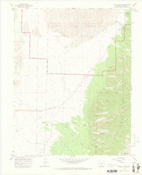
1965 Map of Zapata Ranch
USGS Topo · Published 1973About this map
The Great Sand Dunes National Monument dominates the northern half of this landscape, where shifting dunes meet the western slopes of the Sangre de Cristo Mountains. Along the base of these mountains, the historic Zapata Ranch and the small settlement of Zapata sit near the transition to the Rio Grande National Forest. This mid-1960s survey captures the infrastructure of the monument during a period of established tourism, showing the Entrance Station, Visitor Center, and Pinyon Flats Campground. Hydrology is central to the area's character, with numerous drainages like Mosca Creek and North Zapata Creek flowing toward the valley floor, while a series of flowing wells and a small Cem reflect the ranching and local history of Alamosa County. The rugged eastern terrain is marked by high-altitude features such as Middle Zapata Creek Lake and the prominent Sheep Ridge.
Find a feature on this map
38 named features on this map. Tap any name to fly to it.
Don’t see what you’re looking for? This feature index may not catch every label — zoom into the map to look around manually.
Map Details
Editions of this 1965 Zapata Ranch Map
4 editions found
Other maps of this area

1889 · Huerfano Park
USGS Topo · 1:125,000

1892 · Huerfano Park
USGS Topo · 1:125,000

1954 · Trinidad
USGS Topo · 1:250,000

1955 · Trinidad
USGS Topo · 1:250,000

1958 · Trinidad
USGS Topo · 1:250,000

1959 · Trinidad
USGS Topo · 1:250,000

1965 · Medano Ranch
USGS Topo · 1:24,000

1965 · Zapata Ranch
USGS Topo · 1:24,000

1965 · Dry Lakes
USGS Topo · 1:24,000

1965 · Twin Peaks
USGS Topo · 1:24,000