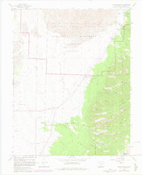
1965 Map of Zapata Ranch
USGS Topo · Published 1982About this map
Zapata Ranch serves as a key landmark in this high-altitude landscape where the Sangre de Cristo foothills meet the floor of the San Luis Valley. The map documents the shifting boundary between the Great Sand Dunes National Monument and the adjacent Rio Grande National Forest, illustrating a complex network of seasonal drainages including North Zapata Creek and Medano Creek. A small Cem and Denton Spring hint at the human history of the ranching frontier, while mid-century park infrastructure is evident in the Visitor Center, an Amphitheater, and the Pinyon Flats Campground. The presence of a Landing Strip and numerous Flowing Wells highlights the logistical adaptations required for life and travel in this arid, geologically unique environment before the 1980s revisions were finalized.
Find a feature on this map
46 named features on this map. Tap any name to fly to it.
Don’t see what you’re looking for? This feature index may not catch every label — zoom into the map to look around manually.
Map Details
Editions of this 1965 Zapata Ranch Map
4 editions found
Other maps of this area

1889 · Huerfano Park
USGS Topo · 1:125,000

1892 · Huerfano Park
USGS Topo · 1:125,000

1954 · Trinidad
USGS Topo · 1:250,000

1955 · Trinidad
USGS Topo · 1:250,000

1958 · Trinidad
USGS Topo · 1:250,000

1959 · Trinidad
USGS Topo · 1:250,000

1965 · Medano Ranch
USGS Topo · 1:24,000

1965 · Zapata Ranch
USGS Topo · 1:24,000

1965 · Dry Lakes
USGS Topo · 1:24,000

1965 · Twin Peaks
USGS Topo · 1:24,000