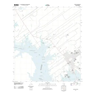
2010 Map of Zapata
USGS Topo · Published 2010About this map
Zapata and its surrounding colonias anchor the eastern shoreline of the Falcon Reservoir, where the international boundary between the United States and Mexico follows the submerged channel of the Rio Grande. The landscape is defined by the expansive waters of the reservoir, punctuated by a series of navigational markers from Buoy Number 3 to Buoy Number 17. In contrast to the modern developments like Falcon Shores and Guzman Colonia, older roots are visible at Old Uribazo and the Urebeno Cemetery. The map detail shows the town's grid expanding into numerous residential developments such as the Manuel Medina Addition Colonia and Ranchito San Jose Colonia, while the hinterland is crossed by seasonal drainages like Chapote Creek and Arroyo Valeriano.
Find a feature on this map
47 named features on this map. Tap any name to fly to it.
Don’t see what you’re looking for? This feature index may not catch every label — zoom into the map to look around manually.
Map Details
Editions of this 2010 Zapata Map
This is the sole edition of this map. No revisions or reprints were ever made.
Other maps of this area

1940 · Mogotes Hill
USGS Topo · 1:62,500

1942 · San Ygnacio
USGS Topo · 1:62,500

1949 · Mc Allen
USGS Topo · 1:250,000

1954 · McAllen
USGS Topo · 1:250,000

1956 · Mogotes Hill
USGS Topo · 1:62,500

1956 · Zapata
USGS Topo · 1:62,500

1956 · Arroyo Clareno
USGS Topo · 1:62,500

1956 · Laredo
USGS Topo · 1:250,000

1957 · Mc Allen
USGS Topo · 1:250,000

1962 · McAllen
USGS Topo · 1:250,000
Featured Places
- Zapata, TX
- Cuellar Colonia, TX
- Falcon Estates Colonia, TX
- Falcon Shores, TX
- Manuel Medina Addition Colonia, TX