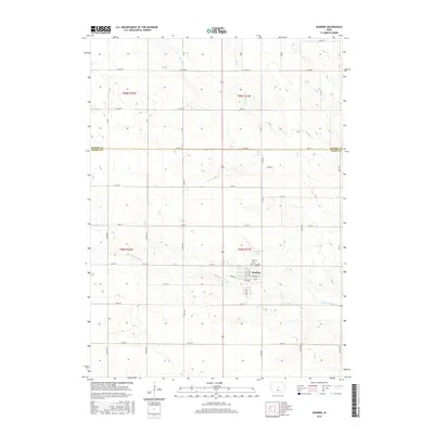
2015 Map of Zearing
USGS Topo · Published 2015About this map
Zearing serves as the primary hub of this Iowa landscape, centered at the intersection of W Main St and E Garfield St. The settlement is defined by its grid-iron street pattern and is flanked by significant local landmarks including the Zearing Cem to the east and the waters of Dakins Lake just to the north. This region of the state is characterized by its systematic agricultural layout, where a dense network of section-line roads like Co Rd D65 and 150th St divide the terrain into precise tracts. The drainage of the land is defined by the winding paths of Minerva Cr and Middle Minerva Cr, which cut through the rectilinear farm plots, illustrating the balance between natural hydrology and the structured human management of the Midwestern prairie.
Find a feature on this map
25 named features on this map. Tap any name to fly to it.
Don’t see what you’re looking for? This feature index may not catch every label — zoom into the map to look around manually.
Map Details
Editions of this 2015 Zearing Map
This is the sole edition of this map. No revisions or reprints were ever made.
Other maps of this area

1954 · Waterloo
USGS Topo · 1:250,000

1955 · Waterloo
USGS Topo · 1:250,000

1975 · Nevada
USGS Topo · 1:24,000

1975 · State Center NW
USGS Topo · 1:24,000

1975 · State Center
USGS Topo · 1:24,000

1975 · Zearing
USGS Topo · 1:24,000

1975 · Mc Callsburg
USGS Topo · 1:24,000
1975 · Colo
USGS Topo · 1:24,000

1979 · New Providence
USGS Topo · 1:24,000

1979 · Hubbard
USGS Topo · 1:24,000