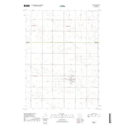
2018 Map of Zearing
USGS Topo · Published 2018About this map
Zearing serves as the central hub for this portion of the Iowa prairie, located just south of the boundary between Hardin Co and Story Co. The town's grid is anchored by W Main St and E Main St, with the Zearing Cem situated on its northern edge near the banks of Middle Minerva Cr. This drainage, along with Minerva Cr and Dakins Lake, defines the local topography, which is otherwise dominated by the precise mile-square sections of the Public Land Survey System. The network of county roads, including Co Rd D65 and Co Rd E18, illustrates a landscape deeply committed to agricultural production, where the placement of farmsteads and rural infrastructure follows a geometry established over a century ago. The convergence of these watercourses toward the southeast suggests the natural flow of the land through the townships of Lincoln and Sherman.
Find a feature on this map
26 named features on this map. Tap any name to fly to it.
Don’t see what you’re looking for? This feature index may not catch every label — zoom into the map to look around manually.
Map Details
Editions of this 2018 Zearing Map
This is the sole edition of this map. No revisions or reprints were ever made.
Other maps of this area

1954 · Waterloo
USGS Topo · 1:250,000

1955 · Waterloo
USGS Topo · 1:250,000

1975 · Nevada
USGS Topo · 1:24,000

1975 · State Center NW
USGS Topo · 1:24,000

1975 · State Center
USGS Topo · 1:24,000

1975 · Zearing
USGS Topo · 1:24,000

1975 · Mc Callsburg
USGS Topo · 1:24,000
1975 · Colo
USGS Topo · 1:24,000

1979 · New Providence
USGS Topo · 1:24,000

1979 · Hubbard
USGS Topo · 1:24,000