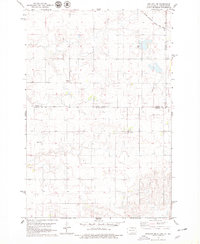
1978 Map of Zeeland NW
USGS Topo · Published 1979About this map
The state line between North Dakota and South Dakota bisects this late-1970s landscape, marking a transition between the rural expanses of Emmons, McIntosh, and Campbell counties. The upper right corner is defined by the Chicago Milwaukee St Paul and Pacific railroad, which cuts a sharp diagonal path through the northern plains. This area is characterized by scattered rural landmarks that serve as vital links to local family history, including the Baptist Cem in the southwest and two separate locations labeled Freidens Cem. These small burial grounds and the rail corridor represent the primary human imprints on a terrain otherwise defined by rolling township and range boundaries.
Find a feature on this map
6 named features on this map. Tap any name to fly to it.
Don’t see what you’re looking for? This feature index may not catch every label — zoom into the map to look around manually.
Map Details
Editions of this 1978 Zeeland NW Map
This is the sole edition of this map. No revisions or reprints were ever made.
Other maps of this area

1953 · Jamestown
USGS Topo · 1:250,000

1953 · McIntosh
USGS Topo · 1:250,000

1954 · Aberdeen
USGS Topo · 1:250,000

1954 · Bismarck
USGS Topo · 1:250,000

1956 · Aberdeen
USGS Topo · 1:250,000

1956 · Jamestown
USGS Topo · 1:250,000

1958 · Bismarck
USGS Topo · 1:250,000

1958 · McIntosh
USGS Topo · 1:250,000

1965 · Herreid NE
USGS Topo · 1:24,000

1965 · Herreid
USGS Topo · 1:24,000