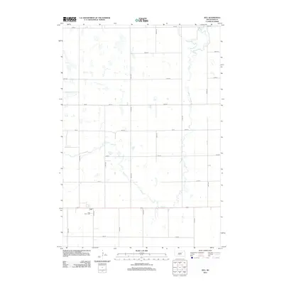
2012 Map of Zell
USGS Topo · Published 2012About this map
Zell serves as a small but vital rural anchor in this pocket of Faulk County. This 2012 survey shows a prairie landscape defined by its grid-pattern section lines and the winding course of the S Fork Snake Cr as it moves through the eastern portion of the quadrangle. The map captures the spatial arrangement of this South Dakota community in the early 21st century, where the local road network and the gentle drainage of the creek continue to shape the agricultural character of the region. Researchers and those with family ties to the area can observe the relationship between the township roads and the natural watercourses that have historically influenced land use in this part of the state.
Find a feature on this map
2 named features on this map. Tap any name to fly to it.
Don’t see what you’re looking for? This feature index may not catch every label — zoom into the map to look around manually.
Map Details
Editions of this 2012 Zell Map
This is the sole edition of this map. No revisions or reprints were ever made.
Other maps of this area

1899 · Northville
USGS Topo · 1:125,000

1899 · Redfield
USGS Topo · 1:125,000

1953 · Redfield North
USGS Topo · 1:24,000

1953 · Huron
USGS Topo · 1:250,000

1954 · Aberdeen
USGS Topo · 1:250,000

1954 · Huron
USGS Topo · 1:250,000

1956 · Aberdeen
USGS Topo · 1:250,000
1960 · Athol
USGS Topo · 1:24,000

1966 · Cresbard SE
USGS Topo · 1:24,000
1966 · Northville SW
USGS Topo · 1:24,000