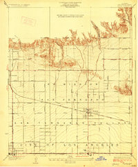
1928 Map of Zelzah
USGS Topo · Published 1928About this map
The San Fernando Valley reveals a period of rapid agricultural and suburban transition in the late 1920s. Centered on the community of Zelzah, this survey highlights a landscape still defined by large land grants like the Ex Mission San Fernando while moving toward organized residential and agricultural development. The presence of the Weeks Poultry Colony illustrates the era’s specialized farming ventures, while the established settlements of Chatsworth, Owensmouth, and Reseda anchor the grid-based expansion. Transport networks are a primary focus, featuring the heavy rail of the Southern Pacific and the interurban lines of the Pacific Electric. Above the emerging street grid, the Santa Susana foothills are carved by Browns Canyon and Limekiln Canyon, showing the sharp contrast between the developing valley floor and the rugged northern city boundary.
Find a feature on this map
38 named features on this map. Tap any name to fly to it.
Don’t see what you’re looking for? This feature index may not catch every label — zoom into the map to look around manually.
Map Details
Editions of this 1928 Zelzah Map
This is the sole edition of this map. No revisions or reprints were ever made.
Other maps of this area

1894 · Los Angeles
USGS Topo · 1:62,500

1896 · Santa Monica
USGS Topo · 1:62,500

1898 · Santa Monica
USGS Topo · 1:62,500

1900 · Los Angeles
USGS Topo · 1:62,500

1900 · Fernando
USGS Topo · 1:62,500

1901 · Southern California Sheet No. 1
USGS Topo · 1:250,000

1902 · Santa Monica
USGS Topo · 1:62,500

1903 · Calabasas
USGS Topo · 1:62,500

1903 · Camulos
USGS Topo · 1:125,000

1903 · Santa Susana
USGS Topo · 1:62,500
Featured Places
- Los Angeles, CA
- Deer Lake Highlands, Unincorporated Chatsworth
- Unincorporated Chatsworth, CA
- Los Angeles County, CA
- United States