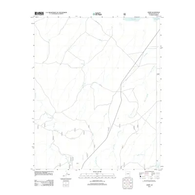
2011 Map of Zeniff
USGS Topo · Published 2011About this map
Zeniff sits at the heart of this high-desert landscape in Navajo County, where the topography is defined by a sophisticated network of water management features and seasonal drainages. Numerous tanks named for local families and landmarks, such as Homestead Tank, Purcell Tank, and Charlie Ross Tank, are scattered across the terrain to catch runoff. The drainage patterns of Scott Wash, Pierce Wash, and Phoenix Park Wash dominate the hydrology of the area, all leading toward the large natural depression of Dry Lake in the north. This 2011 survey reveals how the ranching infrastructure adapts to the arid environment, with labels like Fenceline and Duck Lake Rd marking the few established routes through the scrubland. Significant local landmarks such as Sinkhole Tank and Despain Tank provide specific points of interest for those studying the regional geography and land use patterns of northeastern Arizona.
Find a feature on this map
26 named features on this map. Tap any name to fly to it.
Don’t see what you’re looking for? This feature index may not catch every label — zoom into the map to look around manually.
Map Details
Editions of this 2011 Zeniff Map
This is the sole edition of this map. No revisions or reprints were ever made.
Other maps of this area

1886 · Holbrook
USGS Topo · 1:250,000

1893 · Holbrook
USGS Topo · 1:250,000

1954 · Holbrook
USGS Topo · 1:250,000

1957 · Holbrook
USGS Topo · 1:250,000

1958 · Holbrook
USGS Topo · 1:250,000

1960 · Holbrook
USGS Topo · 1:250,000

1961 · Clay Springs
USGS Topo · 1:62,500

1961 · Heber
USGS Topo · 1:62,500

1970 · Red Knoll
USGS Topo · 1:24,000
1971 · Zeniff
USGS Topo · 1:24,000