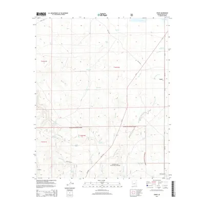
2014 Map of Zeniff
USGS Topo · Published 2014About this map
Zeniff sits at the northeastern edge of this high-desert plateau, overlooking a landscape defined by an intricate network of drainage washes and vital water catchments. The terrain is marked by seasonal watercourses like Scott Wash, Phoenix Park Wash, and Decker Wash, which channel runoff across the arid plains. To the south, the boundary of the Sitgreaves National Forest introduces more varied topography near Long Draw and Bushman Draw.
Find a feature on this map
38 named features on this map. Tap any name to fly to it.
Don’t see what you’re looking for? This feature index may not catch every label — zoom into the map to look around manually.
Map Details
Editions of this 2014 Zeniff Map
This is the sole edition of this map. No revisions or reprints were ever made.
Other maps of this area

1886 · Holbrook
USGS Topo · 1:250,000

1893 · Holbrook
USGS Topo · 1:250,000

1954 · Holbrook
USGS Topo · 1:250,000

1957 · Holbrook
USGS Topo · 1:250,000

1958 · Holbrook
USGS Topo · 1:250,000

1960 · Holbrook
USGS Topo · 1:250,000

1961 · Clay Springs
USGS Topo · 1:62,500

1961 · Heber
USGS Topo · 1:62,500

1970 · Red Knoll
USGS Topo · 1:24,000
1971 · Zeniff
USGS Topo · 1:24,000