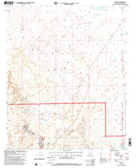
1998 Map of Zeniff
USGS Topo · Published 2000About this map
Sitgreaves National Forest occupies the southern reaches of this landscape, where the terrain shifts into a series of drainages and named washes. To the north, the settlement of Zeniff stands near the head of Scott Wash, marking a point of human habitation in a region otherwise defined by livestock management and water conservation. The map is heavily populated with stock tanks, ranging from the Homestead Tank to family-named points like Charlie Ross Tank and De Spain Tank, reflecting the essential nature of water infrastructure in this arid part of Navajo County.
Find a feature on this map
29 named features on this map. Tap any name to fly to it.
Don’t see what you’re looking for? This feature index may not catch every label — zoom into the map to look around manually.
Map Details
Editions of this 1998 Zeniff Map
This is the sole edition of this map. No revisions or reprints were ever made.
Other maps of this area

1886 · Holbrook
USGS Topo · 1:250,000

1893 · Holbrook
USGS Topo · 1:250,000

1954 · Holbrook
USGS Topo · 1:250,000

1957 · Holbrook
USGS Topo · 1:250,000

1958 · Holbrook
USGS Topo · 1:250,000

1960 · Holbrook
USGS Topo · 1:250,000

1961 · Clay Springs
USGS Topo · 1:62,500

1961 · Heber
USGS Topo · 1:62,500

1970 · Red Knoll
USGS Topo · 1:24,000
1971 · Zeniff
USGS Topo · 1:24,000