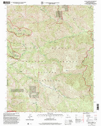
1995 Map of Zigzag Creek
USGS Topo · Published 2000About this map
Tassajara Hot Springs and the surrounding high country of the Santa Lucia Range anchor this mid-1990s survey of the Ventana Wilderness. The map reveals a landscape defined by sharp elevation changes and deep drainages, including the Big Sur Wild and Scenic River and its forks. This era shows a well-established network of backcountry access points, with numerous campsites like Deer Pasture, Pelon Campsite, and Lost Valley Campsite linked by a complex trail system. The presence of the Black Cone Trail and Marble Peak Trail illustrates how travelers navigated the steep ridges between Tassajara Creek and Lost Valley Creek. The layout emphasizes the primitive character of the Los Padres National Forest, where geographical landmarks like Black Cone and Strawberry Valley provided essential orientation for those traversing the interior.
Find a feature on this map
35 named features on this map. Tap any name to fly to it.
Don’t see what you’re looking for? This feature index may not catch every label — zoom into the map to look around manually.
Map Details
Editions of this 1995 Zigzag Creek Map
This is the sole edition of this map. No revisions or reprints were ever made.
Other maps of this area

1915 · Soledad
USGS Topo · 1:62,500

1919 · Junipero Serra
USGS Topo · 1:62,500

1920 · Jamesburg
USGS Topo · 1:48,000

1921 · Jamesburg
USGS Topo · 1:62,500

1921 · Lucia
USGS Topo · 1:62,500

1939 · Jamesburg
USGS Topo · 1:62,500

1940 · Jamesburg
USGS Topo · 1:62,500

1940 · Soledad
USGS Topo · 1:62,500

1941 · Lucia
USGS Topo · 1:62,500

1941 · Junipero Serra
USGS Topo · 1:62,500