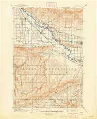
1910 Map of Zillah
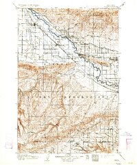
USGS Topo · Published 1948About this map
The Yakima River valley serves as the central artery for this early twentieth-century landscape, where new irrigation systems like the Sunnyside Canal began transforming the arid terrain into a productive agricultural corridor. The Northern Pacific railroad parallels the river, anchoring a string of growing settlements including Toppenish, Wapato, and Zillah. This survey provides a clear view of the complex land use at the time, with the extensive Yakima Indian Reservation occupying the southern half of the quadrangle. High elevation landmarks such as Toppenish Ridge and the Horse Heaven Hills rise sharply from the valley floor, while smaller details like a remote sawmill and the Old State Road reveal the early infrastructure supporting the timber and transit needs of Yakima and Klickitat counties.
Find a feature on this map
35 named features on this map. Tap any name to fly to it.
Don’t see what you’re looking for? This feature index may not catch every label — zoom into the map to look around manually.
Map Details
Editions of this 1910 Zillah Map
3 editions found

Historical Maps of Sunnyside Through Time
1 maps found