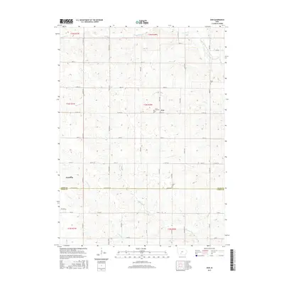
2015 Map of Zion
USGS Topo · Published 2015About this map
The town of Zion and its surrounding countryside in Adair and Union counties are defined by a complex drainage network that includes Ninemile Cr, Threemile Cr, and Twelvemile Cr. This landscape is marked by the transition between the rolling uplands and the river valleys of the Thompson River. The settlement pattern follows a rigid section-line road grid, yet the placement of local landmarks like the Hill of Zion Cem and Liberty Cem reveals the centers of these rural agricultural communities. Near the western edge of the map, the settlement of Spaulding sits along Co RD p33, representing the steady, long-term habitation of this fertile region. Researchers will find a preserved look at the infrastructure of the Iowa plains, from early township boundaries to the precise locations of family burial grounds like Wilson Cem.
Find a feature on this map
49 named features on this map. Tap any name to fly to it.
Don’t see what you’re looking for? This feature index may not catch every label — zoom into the map to look around manually.
Map Details
Editions of this 2015 Zion Map
This is the sole edition of this map. No revisions or reprints were ever made.
Other maps of this area

1951 · Afton
USGS Topo · 1:62,500

1952 · Winterset
USGS Topo · 1:62,500

1954 · Greenfield
USGS Topo · 1:62,500

1954 · Omaha
USGS Topo · 1:250,000

1957 · Omaha
USGS Topo · 1:250,000

1958 · Omaha
USGS Topo · 1:250,000

1980 · Creston East
USGS Topo · 1:24,000

1981 · Zion
USGS Topo · 1:24,000
1981 · Orient
USGS Topo · 1:24,000
1981 · Creston West
USGS Topo · 1:24,000