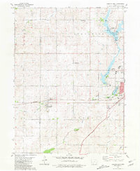
1981 Map of Creston West
USGS Topo · Published 1981About this map
The Burlington Northern railroad corridor anchors this 1981 survey of Union County, passing through the town of Cromwell and into the western edge of Creston. This rail-oriented landscape is defined by the transition from rural agricultural land to growing civic centers, featuring prominent local institutions like Southwestern Community College and the Crestmoor Country Club. To the north, the terrain is shaped by the headwaters of the Platte River and the East Fork Nodaway River, while recreational development is centered around Green Valley State Park.
Find a feature on this map
39 named features on this map. Tap any name to fly to it.
Don’t see what you’re looking for? This feature index may not catch every label — zoom into the map to look around manually.
Map Details
Editions of this 1981 Creston West Map
This is the sole edition of this map. No revisions or reprints were ever made.
Other maps of this area

1954 · Omaha
USGS Topo · 1:250,000

1955 · Nebraska City
USGS Topo · 1:250,000

1957 · Nebraska City
USGS Topo · 1:250,000

1957 · Omaha
USGS Topo · 1:250,000

1958 · Omaha
USGS Topo · 1:250,000

1958 · Nebraska City
USGS Topo · 1:250,000

1980 · Lenox
USGS Topo · 1:24,000

1980 · Nevinville
USGS Topo · 1:24,000

1980 · Creston East
USGS Topo · 1:24,000
1980 · Prescott
USGS Topo · 1:24,000