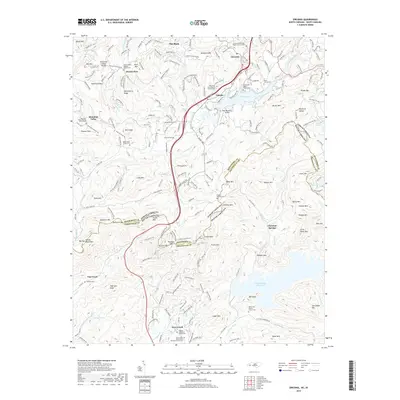
2019 Map of Zirconia
USGS Topo · Published 2019About this map
Lake Summit and the North Saluda Reservoir dominate the hydrology of this borderland, where the Saluda Mountains define the boundary between North Carolina and South Carolina. The settlement of Tuxedo sits near the headwaters of the Green River, surrounded by several historic congregations and their associated burial grounds, including the Zirconia Missionary Baptist Church Cem and Mount Olivet Baptist Church Cem. Further south, the terrain becomes increasingly complex as it descends toward the South Carolina line near Gap Creek and Terry Creek. This 2019 survey documents a landscape where small, family-named landmarks like Hagood - Hightower Family Cem and the Ward Family Cem persist alongside modern infrastructure. The map illustrates how local topography influenced the placement of early settlements like Flat Rock and Zirconia, which were established relative to the winding river valleys and ridge lines of the Blue Ridge foothills.
Find a feature on this map
132 named features on this map. Tap any name to fly to it.
Don’t see what you’re looking for? This feature index may not catch every label — zoom into the map to look around manually.
Map Details
Editions of this 2019 Zirconia Map
This is the sole edition of this map. No revisions or reprints were ever made.
Other maps of this area

1905 · Pisgah
USGS Topo · 1:125,000

1906 · Pisgah
USGS Topo · 1:125,000

1907 · Saluda
USGS Topo · 1:125,000

1935 · Standingstone Mtn.
USGS Topo · 1:24,000

1935 · Horse Shoe
USGS Topo · 1:24,000

1935 · Hendersonville
USGS Topo · 1:24,000

1935 · Fishtop
USGS Topo · 1:24,000

1935 · Zirconia
USGS Topo · 1:24,000
1942 · Horse Shoe
USGS Topo · 1:24,000
1946 · Standingstone Mtn.
USGS Topo · 1:24,000