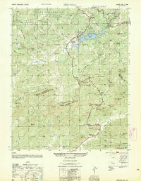
1954 Map of Zirconia
USGS Topo · Published 1954About this map
The Saluda Mountains define this borderland where North Carolina meets South Carolina, a region marked by steep relief and a burgeoning mid-century recreation landscape. Lake Summit serves as a focal point for the northern half of the sheet, surrounded by seasonal retreats and youth camps like Camp Greystone and Camp Noahs Ark. The Southern railroad line parallels the Green River, supporting industrial features such as a Power Plant and Surge Tank. In the southern portion of the quadrangle, the North Fork Saluda River winds past the community of Merrittsville and along the Dixie Highway. This 1954 edition, based on earlier surveys by the Tennessee Valley Authority and the USGS, documents a transition from traditional rural life—evidenced by Mountain Valley Cem and Mount Olivet Ch—to a period of hydroelectric development and early regional tourism.
Find a feature on this map
78 named features on this map. Tap any name to fly to it.
Don’t see what you’re looking for? This feature index may not catch every label — zoom into the map to look around manually.
Map Details
Editions of this 1954 Zirconia Map
This is the sole edition of this map. No revisions or reprints were ever made.
Other maps of this area

1905 · Pisgah
USGS Topo · 1:125,000

1906 · Pisgah
USGS Topo · 1:125,000

1907 · Saluda
USGS Topo · 1:125,000

1935 · Standingstone Mtn.
USGS Topo · 1:24,000

1935 · Horse Shoe
USGS Topo · 1:24,000

1935 · Hendersonville
USGS Topo · 1:24,000

1935 · Fishtop
USGS Topo · 1:24,000

1935 · Zirconia
USGS Topo · 1:24,000
1942 · Horse Shoe
USGS Topo · 1:24,000
1946 · Standingstone Mtn.
USGS Topo · 1:24,000