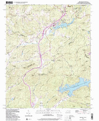
1997 Map of Zirconia
USGS Topo · Published 2001About this map
Zirconia and the village of Tuxedo occupy a high mountain landscape where the Blue Ridge Divide meets the Saluda Mountains. This late-twentieth-century update shows a region defined by its water and recreational history, anchored by the Green River and the sprawling Lake Summit. The map documents a cluster of youth and community camps that became a hallmark of this Henderson County corridor, including Camp Windy Wood, Camp Green Cove, and Camp Arrowhead.
Find a feature on this map
102 named features on this map. Tap any name to fly to it.
Don’t see what you’re looking for? This feature index may not catch every label — zoom into the map to look around manually.
Map Details
Editions of this 1997 Zirconia Map
This is the sole edition of this map. No revisions or reprints were ever made.
Other maps of this area

1905 · Pisgah
USGS Topo · 1:125,000

1906 · Pisgah
USGS Topo · 1:125,000

1907 · Saluda
USGS Topo · 1:125,000

1935 · Standingstone Mtn.
USGS Topo · 1:24,000

1935 · Horse Shoe
USGS Topo · 1:24,000

1935 · Hendersonville
USGS Topo · 1:24,000

1935 · Fishtop
USGS Topo · 1:24,000

1935 · Zirconia
USGS Topo · 1:24,000
1942 · Horse Shoe
USGS Topo · 1:24,000
1946 · Standingstone Mtn.
USGS Topo · 1:24,000