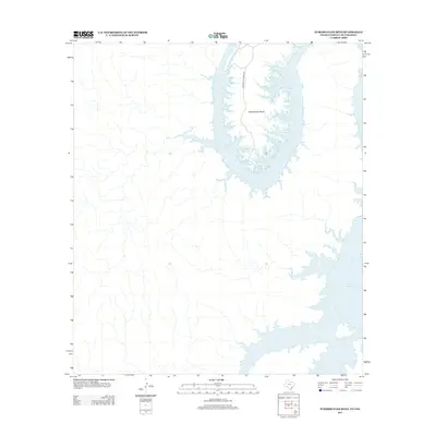
2013 Map of Zuberbueler Bend
USGS Topo · Published 2013About this map
Amistad Reservoir dominates this borderland geography where the water fills the deep incisions of the limestone landscape. The focal point is Zuberbueler Bend, a massive peninsula-like formation created by the winding course of the submerged river valley. This specific area is marked by its isolation and limited infrastructure, with Zuberbueler Ranch Rd serving as the primary corridor into the rugged interior of the bend. The map illustrates the complex shoreline of the reservoir, showing how the rising waters have transformed the drainage basins into a series of intricate inlets and fingers that stretch into the surrounding ranchland. This 2013 U.S. Geological Survey data provides a clear view of the modern water levels and the specific access points available for this remote section of the international boundary.
Find a feature on this map
3 named features on this map. Tap any name to fly to it.
Don’t see what you’re looking for? This feature index may not catch every label — zoom into the map to look around manually.
Map Details
Editions of this 2013 Zuberbueler Bend Map
This is the sole edition of this map. No revisions or reprints were ever made.
Other maps of this area

1941 · Feely
USGS Topo · 1:62,500

1943 · Devils River
USGS Topo · 1:62,500

1944 · Devils River
USGS Topo · 1:62,500

1944 · Mouth Of Pecos
USGS Topo · 1:62,500

1958 · Del Rio
USGS Topo · 1:250,000

1964 · Del Rio
USGS Topo · 1:250,000
1972 · Zuberbueler Bend NW
USGS Topo · 1:24,000

1972 · Seminole Canyon
USGS Topo · 1:24,000
1972 · Zuberbueler Bend
USGS Topo · 1:24,000
1972 · Box Canyon
USGS Topo · 1:24,000