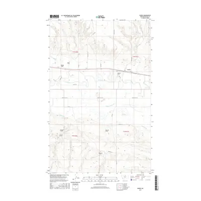
2017 Map of Zurich
USGS Topo · Published 2017About this map
The Milk River meanders through the heart of this Blaine County landscape, defining the agricultural and transport corridor of the northern plains. The settlement of Zurich sits along the rail line and highway, serving as a focal point for the surrounding ranching and farming operations. The influence of water management on the high plains is evident through the extensive network of irrigation features, including the Paradise Valley Canal, Hillside Ditch, and Snake Cr Ditch.
Find a feature on this map
32 named features on this map. Tap any name to fly to it.
Don’t see what you’re looking for? This feature index may not catch every label — zoom into the map to look around manually.
Map Details
Editions of this 2017 Zurich Map
This is the sole edition of this map. No revisions or reprints were ever made.
Other maps of this area

1904 · Chinook
USGS Topo · 1:62,500

1905 · Harlem
USGS Topo · 1:62,500

1912 · Zurich
USGS Topo · 1:125,000

1913 · Cherry Ridge
USGS Topo · 1:125,000

1953 · Havre
USGS Topo · 1:250,000

1956 · Cleveland
USGS Topo · 1:62,500

1957 · Havre
USGS Topo · 1:250,000

1958 · Havre
USGS Topo · 1:250,000
1964 · Big Coulee
USGS Topo · 1:24,000

1964 · Rabbit Hills
USGS Topo · 1:24,000