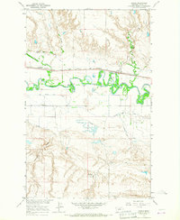
1964 Map of Zurich
USGS Topo · Published 1967About this map
The winding Milk River valley defines the character of this 1960s Blaine County landscape, where the small settlement of Zurich sits as a vital point along the Great Northern railroad line. This survey, conducted as part of the Department of the Interior's Missouri River Basin development program, illustrates a complex irrigation infrastructure designed to manage the arid plains. Systems such as the Fort Belknap Canal, Paradise Valley Canal, and Hillside Ditch lace the river bottomlands, supporting the region's agricultural heartbeat. North of the river, the terrain breaks into sharp coulees like Coal Coulee and Fifteenmile Creek. To the south, the North Fork Sch and the Hebbelman Landing Field provide evidence of the scattered rural community's infrastructure during the mid-20th century.
Find a feature on this map
17 named features on this map. Tap any name to fly to it.
Don’t see what you’re looking for? This feature index may not catch every label — zoom into the map to look around manually.
Map Details
Editions of this 1964 Zurich Map
This is the sole edition of this map. No revisions or reprints were ever made.
Other maps of this area

1904 · Chinook
USGS Topo · 1:62,500

1905 · Harlem
USGS Topo · 1:62,500

1912 · Zurich
USGS Topo · 1:125,000

1913 · Cherry Ridge
USGS Topo · 1:125,000

1953 · Havre
USGS Topo · 1:250,000

1956 · Cleveland
USGS Topo · 1:62,500

1957 · Havre
USGS Topo · 1:250,000

1958 · Havre
USGS Topo · 1:250,000
1964 · Big Coulee
USGS Topo · 1:24,000

1964 · Rabbit Hills
USGS Topo · 1:24,000