1920s Maps of Baldwin County, Alabama
Explore 9 historic maps of Baldwin County from the 1920s. These maps offer a rare glimpse into what life looked like during the 1920s — showing old roads, neighborhoods, homes, and landmarks that have changed or disappeared over time.
Whether you're researching your family's past, planning a metal detecting trip, or studying how Baldwin County's landscape evolved across the 1920s, these high-resolution maps are a powerful tool for exploring the history of this region.
- Focus on a specific era: All maps on this page are from the 1920s, giving you a focused view of this time period.
- See what’s changed: Compare century-old streets, trails, and buildings to today's modern landscape using overlays and satellite layers.
- Research with precision: Use these maps for genealogy, historical research, land use analysis, or educational projects.
- View, download, or print: Maps are fully viewable online in high resolution, and can be downloaded or printed for your own records.
Start exploring Baldwin County's history through authentic maps from the 1920s. This is your window into the past.
Baldwin County, AL maps
(9)- 1920 Map of Robertsdale
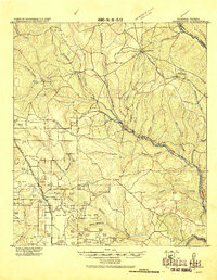 1920 Robertsdale1920 Print · USGSBaldwin County at the end of the Great War reveals a landscape defined by the timber industry and early rail expansion. Genealogists can trace the rural footprints of Silverhill and Gateswood or follow the Logging Spur lines through the Burned Woods.
 - 1921 Map of Bon Secour
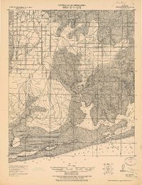 1921 Bon Secour1921 Print · USGSThe Alabama coast is captured here in the early twentieth century, showing a landscape of rail-connected towns and untouched shorelines. Researchers can trace early infrastructure like the Ft. Morgan and Summerdale RR and find quiet coastal outposts like Josephine P.O. and Bon Secour.2 unique versions available
 - 1921 Map of Point Clear
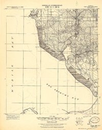 1921 Point Clear1921 Print · USGSThe eastern shore of Mobile Bay and its tidal inlets are captured here in the years following the Great War. Researchers can trace early coastal settlements like Point Clear, find family names at Seymours Bluff, and locate the historic Dixie Road corridor.2 unique versions available
 - 1921 Map of Fairhope
 1921 Fairhope1921 Print · USGSThe eastern shore of Mobile Bay comes alive in the early twentieth century as coastal colonies and timber towns expand. Trace the early streets of Fairhope and Daphne or follow the New Orleans Mobile and Pensacola R. R. through Loxley.
 - 1921 Map of Dauphin Island
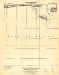 1921 Dauphin Island1921 Print · USGSThe entrance to Mobile Bay comes alive in the early twentieth century as a landscape of coastal defense and maritime navigation. You can trace the battery positions at Fort Morgan and Fort Gaines or locate the Sand Island Light.
 - 1921 Map of Fort Barrancas
 1921 Fort Barrancas1921 Print · USGSThe Florida-Alabama coast at the start of the 1920s reveals a landscape defined by naval history and maritime industry. Researchers can trace the military layout of Ft. Barrancas, locate Pensacola Light, and find vanished streets in Woolsey.
 - 1921 Map of Muscogee
 1921 Muscogee1921 Print · USGSThe Alabama-Florida borderlands come to life in the early 1920s, showing the river-and-rail network that sustained the region. Trace old ferry crossings like Billy Malone Ferry and landmarks such as Lathams Chapel and Seminola P.O.
 - 1921 Map of Delchamps
 1921 Delchamps1921 Print · USGSCoastal Mobile County comes alive in this early twentieth-century survey of the bays and sounds before modern development. Genealogists and historians can trace family-named settlements like Delchamps and Prosser, or locate maritime landmarks such as the Oyster Factory and the Mobile & Ohio RR.
 - 1922 Map of Mobile
 1922 Mobile1922 Print · USGSMobile and its coastal defenses are revealed in the early twentieth century as the city's rail and maritime networks expanded toward the bay. Genealogists and historians can trace family-named routes and vanished stations like Mertz Sta., Knobloch's Wharf., and Spring Hill College.
End of results
Showing maps 1-9 of 9
Top cities of Baldwin County
- Daphne historical maps
- Fairhope historical maps
- Foley historical maps
- Gulf Shores historical maps
- Spanish Fort historical maps
- Bay Minette historical maps
See more
Frequently asked questions
- What are the different types of historical maps available for Baldwin County?
- What is the oldest map of Baldwin County?
- Where can I purchase historical maps of Baldwin County for my home or office?
- Where can I download high-res historical maps of Baldwin County?
- Are there historical topographic maps available for Baldwin County?
- Is there historical aerial imagery available for Baldwin County?
- Where are historical maps of Baldwin County sourced from?