1970s Maps of Baldwin County, Alabama
Explore 12 historic maps of Baldwin County from the 1970s. These maps offer a rare glimpse into what life looked like during the 1970s — showing old roads, neighborhoods, homes, and landmarks that have changed or disappeared over time.
Whether you're researching your family's past, planning a metal detecting trip, or studying how Baldwin County's landscape evolved across the 1970s, these high-resolution maps are a powerful tool for exploring the history of this region.
- Focus on a specific era: All maps on this page are from the 1970s, giving you a focused view of this time period.
- See what’s changed: Compare century-old streets, trails, and buildings to today's modern landscape using overlays and satellite layers.
- Research with precision: Use these maps for genealogy, historical research, land use analysis, or educational projects.
- View, download, or print: Maps are fully viewable online in high resolution, and can be downloaded or printed for your own records.
Start exploring Baldwin County's history through authentic maps from the 1970s. This is your window into the past.
Baldwin County, AL maps
(12)- 1970 Map of Lillian, 1971 Print
 1970 Lillian1971 Print · USGSThe Alabama-Florida state line comes alive in the early seventies, showcasing a coastal landscape defined by naval aviation and deep-rooted heritage. Genealogists and historians can trace Lillian landmarks like St Josephs Ch and the Old Spanish Cem or locate the sprawling Bronson Field.4 unique versions available
 - 1970 Map of Perdido Bay, 1971 Print
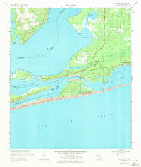 1970 Perdido Bay1971 Print · USGSPerdido Bay and the surrounding coastal reaches of Florida and Alabama are shown here during the early seventies. Researchers can trace the development of beachside communities like Seaglades and Gulf Beach or locate early marinas such as Holiday Harbor Marina.4 unique versions available
 - 1970 Map of West Pensacola, 1972 Print
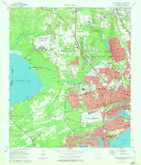 1970 West Pensacola1972 Print · USGSCoastal Florida is shown in the era of naval expansion and suburban growth between Perdido and Pensacola Bays. Genealogists and researchers can trace family landmarks like Spring Hill Ch, old schools such as Myrtle Grove Sch, and the grounds of Saufley Field.2 unique versions available
 - 1972 Map of Chrysler, 1974 Print
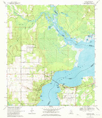
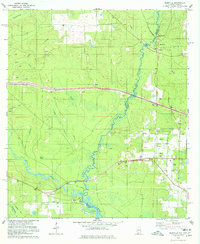
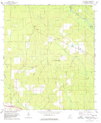
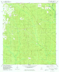
 1972 Chrysler1974 Print · USGSMonroe County and the Baldwin county line are mapped here in the early seventies as the river-and-rail landscape was shifting. Genealogists and local historians can locate several family-named landmarks and rural centers, including Eliska, Mamies Chapel, and Shomo Cem.2 unique versions available
 - 1978 Map of Seminole
 1978 Seminole1978 Print · USGSThe borderlands of Alabama and Florida come alive in the late 1970s, defined by the winding Perdido River and rural industry. Researchers can trace family history at Old Muscogee Cem or explore the transit history of the St Louis - San Francisco RR.3 unique versions available
 - 1978 Map of Dyas
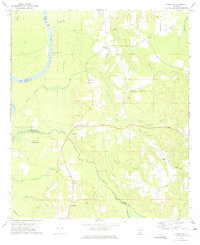
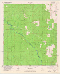
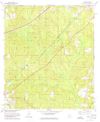 1978 Dyas1978 Print · USGSBaldwin County in the late seventies is captured here at the intersection of timber-rich wetlands and the historic Louisville and Nashville rail line. Genealogists can trace family footprints around Perdido, Phillipsville, and rural congregations like New Providence Ch.3 unique versions available
 - 1978 Map of Barrineau Park
 1978 Barrineau Park1978 Print · USGSThe Perdido River forms the border between Florida and Alabama in the late seventies, winding through a landscape of timber and creek-fed bottomlands. You can trace family roots at Barrineau Park, follow the St Louis-San Francisco line, or locate rural sites like Pugh Chapel and Lathram Chapel.3 unique versions available
 - 1978 Map of Walnut Hill
 1978 Walnut Hill1978 Print · USGSThe Florida-Alabama borderlands along the Perdido River are shown here in the late seventies as a landscape of timber, rail, and rural crossroads. Researchers can locate family landmarks like Antioch Ch, the Dutch Cem, and the rail corridor of the St Louis - San Francisco.3 unique versions available
 - 1978 Map of Gateswood
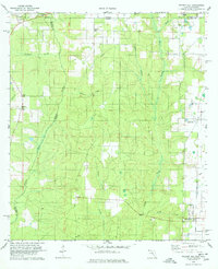
 1978 Gateswood1978 Print · USGSThe Alabama-Florida borderlands near the Perdido River are captured here in the late seventies. Researchers can trace rural community foundations at Hamilton Ch, the Bellefontaine Sch, and Pittman Cem along with several industrial claypits.5 unique versions available
 - 1978 Map of Dogwood Creek
 1978 Dogwood Creek1978 Print · USGSThe borderlands of Baldwin County, Alabama, and Escambia County, Florida, appear here in the late seventies as a landscape of timber and infrastructure. Genealogists and local historians can trace the paths of Brady Road and find landmarks like High Pine Cem and the settlement at Pine Grove.4 unique versions available
 - 1978 Map of Enon
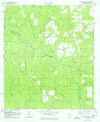
 1978 Enon1978 Print · USGSThe Florida-Alabama borderlands in the late seventies were defined by the winding Perdido River and rural timber tracts. Genealogists can locate family landmarks like Holly Grove Cem, Dry Springs Ch, and the small settlement of Enon.4 unique versions available
 - 1978 Map of Pensacola, 1980 Print
 1978 Pensacola1980 Print · USGSThe Gulf Coast at the end of the 1970s reveals a landscape shaped by maritime industry and a heavy naval presence. Researchers can trace the development of Pensacola alongside quiet coastal hamlets like Magnolia Springs and the historic Fort Pickens State Park.3 unique versions available
End of results
Showing maps 1-12 of 12
Top cities of Baldwin County
- Daphne historical maps
- Fairhope historical maps
- Foley historical maps
- Gulf Shores historical maps
- Spanish Fort historical maps
- Bay Minette historical maps
See more
Frequently asked questions
- What are the different types of historical maps available for Baldwin County?
- What is the oldest map of Baldwin County?
- Where can I purchase historical maps of Baldwin County for my home or office?
- Where can I download high-res historical maps of Baldwin County?
- Are there historical topographic maps available for Baldwin County?
- Is there historical aerial imagery available for Baldwin County?
- Where are historical maps of Baldwin County sourced from?