1980s Maps of Baldwin County, Alabama
Explore 30 historic maps of Baldwin County from the 1980s. These maps offer a rare glimpse into what life looked like during the 1980s — showing old roads, neighborhoods, homes, and landmarks that have changed or disappeared over time.
Whether you're researching your family's past, planning a metal detecting trip, or studying how Baldwin County's landscape evolved across the 1980s, these high-resolution maps are a powerful tool for exploring the history of this region.
- Focus on a specific era: All maps on this page are from the 1980s, giving you a focused view of this time period.
- See what’s changed: Compare century-old streets, trails, and buildings to today's modern landscape using overlays and satellite layers.
- Research with precision: Use these maps for genealogy, historical research, land use analysis, or educational projects.
- View, download, or print: Maps are fully viewable online in high resolution, and can be downloaded or printed for your own records.
Start exploring Baldwin County's history through authentic maps from the 1980s. This is your window into the past.
Baldwin County, AL maps
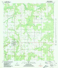
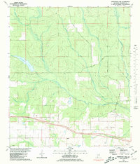
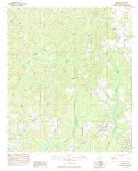
(30)- 1980 Map of Bay Minette North
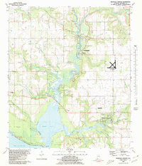
 1980 Bay Minette North1980 Print · USGSBay Minette and Stockton are captured during a period of steady growth in 1980, centered around the Louisville and Nashville rail line. Genealogists can locate family landmarks like Stockton Memorial Cem and Greater St John Ch.
 - 1980 Map of Magnolia Springs
 1980 Magnolia Springs1980 Print · USGSCoastal Baldwin County is captured here in the late seventies, showing the tidal reach of Weeks Bay and the riverfront community of Magnolia Springs. Genealogists can locate family landmarks like Brook Cedron Cem, Clay City, and the Fish River Ch.3 unique versions available
 - 1980 Map of Orange Beach
 1980 Orange Beach1980 Print · USGSCoastal Alabama was entering a new era of development in the late seventies, centered on the waterways of Baldwin County. Local historians can trace the early layouts of Orange Beach, the residential expansion on Ono Island, and landmarks like Lay Cem or the U S Naval Res Wolf Field.2 unique versions available
 - 1980 Map of St. Andrews Bay
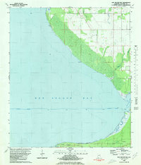
 1980 St. Andrews Bay1980 Print · USGSThe Alabama coastline along the Fort Morgan peninsula is captured here in the late 1970s, showcasing the thin strip of land between Mobile Bay and the Gulf. Genealogists and local historians can locate early coastal settlements like Weeks and Edith.
 - 1980 Map of Bon Secour Bay
 1980 Bon Secour Bay1980 Print · USGSCoastal Baldwin County is captured here in the late seventies, showing the vital maritime corridor where the Intracoastal Waterway meets the bay. Genealogists and local historians can locate Gasque, Shellbank Ch, and Miller Memorial Cem along the southern shore.2 unique versions available
 - 1980 Map of Little Point Clear
 1980 Little Point Clear1980 Print · USGSThe Alabama Gulf Coast's maritime character is preserved here during the early 1980s, focusing on the waters where the bay meets the sound. Trace the path of the Intracoastal Waterway past Little Point Clear and the shallow Tidal Flat of Saxon Bay.
 - 1980 Map of Gulf Shores
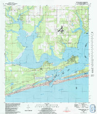
 1980 Gulf Shores1980 Print · USGSGulf Shores and the Baldwin County coast are captured here in 1980, showcasing a landscape of maritime industry and early tourism. Trace the development of the Intracoastal Waterway and locate local landmarks like Swift Sch and Jack Edwards Airport.2 unique versions available
 - 1980 Map of Pine Beach
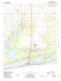
 1980 Pine Beach1980 Print · USGSThe Alabama coast is captured here in the early eighties, showing the thin barrier peninsula between Little Lagoon and the sea. Researchers can trace the early development of Gulf Shores and find local landmarks like Gator Lake and Edith Hammock.
 - 1980 Map of Elberta, 1981 Print
 1980 Elberta1981 Print · USGSThe coastal plains of Baldwin County in the 1980s reveal a landscape of naval reservations and small-town growth. Trace family history at St Marks Cem or explore the outskirts of Elberta near the Horak Airport.2 unique versions available
 - 1980 Map of Foley, 1981 Print
 1980 Foley1981 Print · USGSBaldwin County at the start of the 1980s was a hub of aviation and rail transport as these Gulf Coast communities expanded. Local historians can trace the Louisville and Nashville rail line and locate landmarks like the OLF Barin U S Naval Reservation and Pine Rest Cemetery.2 unique versions available
 - 1980 Map of The Basin, 1981 Print
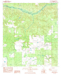
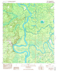
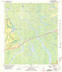 1980 The Basin1981 Print · USGSThe Mobile-Tensaw Delta is captured here during the 1980s, revealing a complex network of bayous and river bends. Local historians can locate the Fort Louis Historical Marker and trace the winding paths of Bayou Dead Lake and Bayou Fisher.3 unique versions available
 - 1980 Map of Elsanor, 1981 Print
 1980 Elsanor1981 Print · USGSBaldwin County’s interior landscape is shown here in the early eighties as a network of river-bound communities and timberlands. Local historians can trace family roots through the Greek Cem and Foley Cem or locate former landmarks like the Seminole Lookout Tower.3 unique versions available
 - 1980 Map of Robertsdale, 1981 Print
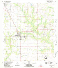 1980 Robertsdale1981 Print · USGSBaldwin County centers on the thriving rail-and-road junctions of Robertsdale and Silverhill during the early eighties. Genealogists and historians can trace local landmarks like Baldwin Mem Cem, the OLF Summerdale US Naval Res, and the old Louisville and Nashville line.2 unique versions available
 - 1980 Map of Steelwood Lake, 1981 Print
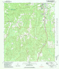
 1980 Steelwood Lake1981 Print · USGSBaldwin County in the early eighties reveals a landscape of winding river basins and growing rural communities. Genealogists and historians can trace family landmarks like Rosinton Ch, Dyes Cem, and the path of the Old Railroad Grade.2 unique versions available
 - 1980 Map of Bay Minette South, 1981 Print
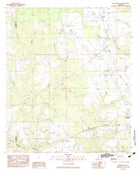
 1980 Bay Minette South1981 Print · USGSBaldwin County in the early eighties shows the expansion of Bay Minette alongside the enduring rural character of its outlying communities. Researchers can trace local heritage through landmarks like Faulkner State Jr College, Whitehouse Forks, and the Johnson Cem.2 unique versions available
 - 1981 Map of Bay Minette
 1981 Bay Minette1981 Print · USGSThe Alabama-Florida borderlands come to life in the early 1980s as the river delta meets the growing coastal communities. Researchers can trace the Louisville and Nashville rail lines or locate historical points like Twenty-two Mile Bluff and the Blackwater River State Forest.2 unique versions available
 - 1982 Map of Biloxi
 1982 Biloxi1982 Print · USGSThe Mississippi and Alabama coastlines are captured in the early eighties as industrial hubs and wildlife refuges shaped the shoreline. Trace maritime and military history through Fort Morgan, Keesler Air Force Base, and the barrier islands of Gulf Islands National Seashore.2 unique versions available
 - 1983 Map of McCullough
 1983 McCullough1983 Print · USGSThe Alabama borderlands near the Baldwin and Escambia county line are captured here in the early 1980s. Genealogists and local historians can trace family roots at Booneville Ch & Cem, Lindsey Cem, and the settlement of Jack Springs.
 - 1983 Map of Vaughn
 1983 Vaughn1983 Print · USGSThe river landings and upland settlements of Baldwin County are captured here in the early eighties. Researchers can trace family sites at Lancaster Cem, locate Latham Ch, or find river access points like Hubbard Landing and Nelson Landing.
 - 1983 Map of Blacksher
 1983 Blacksher1983 Print · USGSThe rural border of Baldwin and Monroe counties is captured here in the early 1980s, showing a landscape shaped by creek networks and timber lookouts. Researchers can locate the Blacksher community and Redtown, or trace landmarks like the Lottie Lookout Tower and old Wooden Piers.
 - 1983 Map of Perdido
 1983 Perdido1983 Print · USGSBaldwin County in the early eighties shows a rural landscape where timber and transport intersect at the L & N railroad line. Genealogists and local historians can trace small communities like Rabun and Lottie through landmarks like Guys Chapel Cem and Pleasant Plains Ch.
 - 1983 Map of Bilbo Island
 1983 Bilbo Island1983 Print · USGSThe confluence of the Alabama and Tombigbee Rivers is captured here in the early 1980s, marking the boundary of four coastal counties. Researchers can trace river landmarks and backwater features like Little Shanty Landing, Bilbo Lake, and the headwaters of the Mobile River.2 unique versions available
 - 1983 Map of Stiggings Lake
 1983 Stiggings Lake1983 Print · USGSThe river delta between Mobile and Baldwin counties is captured here in the early eighties, showcasing a labyrinth of wetlands and historic landings. Researchers can trace the sites of Ft Stoddard and an Indian Mound, or locate local landmarks like Belsaw Sch and Meathers Landing.2 unique versions available
 - 1983 Map of Freemanville
 1983 Freemanville1983 Print · USGSEscambia County's borderlands are detailed in this early 1980s survey, showing the rural communities of Poarch and Freemanville at a crossroads of rail and river. Genealogists can locate Mothershed Cem or trace family roots near St Annas Ch and Nokomis.
 - 1983 Map of Tensaw
 1983 Tensaw1983 Print · USGSThe Alabama River corridor near the Baldwin and Clarke county line comes to life in the early eighties. Genealogists and historians can locate Fort Mimms (Historical), Montgomery Hill, and rural churches like St Matthews Ch.
Showing maps 1-25 of 30
Top cities of Baldwin County
- Daphne historical maps
- Fairhope historical maps
- Foley historical maps
- Gulf Shores historical maps
- Spanish Fort historical maps
- Bay Minette historical maps
See more
Frequently asked questions
- What are the different types of historical maps available for Baldwin County?
- What is the oldest map of Baldwin County?
- Where can I purchase historical maps of Baldwin County for my home or office?
- Where can I download high-res historical maps of Baldwin County?
- Are there historical topographic maps available for Baldwin County?
- Is there historical aerial imagery available for Baldwin County?
- Where are historical maps of Baldwin County sourced from?