1940s Maps of Bay Minette, Alabama
Explore 4 historic maps of Bay Minette from the 1940s. These maps offer a rare glimpse into what life looked like during the 1940s — showing old roads, neighborhoods, homes, and landmarks that have changed or disappeared over time.
Whether you're researching your family's past, planning a metal detecting trip, or studying how Bay Minette's landscape evolved across the 1940s, these high-resolution maps are a powerful tool for exploring the history of this region.
- Focus on a specific era: All maps on this page are from the 1940s, giving you a focused view of this time period.
- See what’s changed: Compare century-old streets, trails, and buildings to today's modern landscape using overlays and satellite layers.
- Research with precision: Use these maps for genealogy, historical research, land use analysis, or educational projects.
- View, download, or print: Maps are fully viewable online in high resolution, and can be downloaded or printed for your own records.
Start exploring Bay Minette's history through authentic maps from the 1940s. This is your window into the past.
Bay Minette, AL maps
(4)- 1941 Map of Bay Minette, 1955 Print
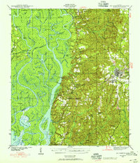 1941 Bay Minette1955 Print · USGSCoastal Alabama at the start of the 1940s is defined here by the complex river delta and the timber-rich uplands of Baldwin County. Genealogists and historians can trace old community centers like Whitehouse Forks, schools such as Stockton Sch, and the path of the Louisville and Nashville RR.2 unique versions available
 - 1942 Map of Dyas, 1965 Print
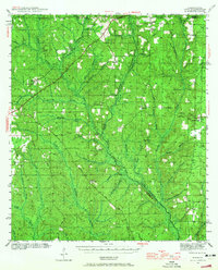 1942 Dyas1965 Print · USGSThe borderlands of Alabama and Florida are captured here during the early 1940s, highlighting a landscape shaped by timber and the Perdido River. Genealogists can locate family landmarks like Cain Cem, Nokomis Sch, and the St Stephens and St Louis RR.2 unique versions available
 - 1943 Map of Bay Minette
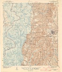 1943 Bay Minette1943 Print · USGSCoastal Alabama settlements and river landings appear in detail during the early 1940s. Researchers can trace the Louisville and Nashville rail lines through Bay Minette and locate family landmarks like Douglasville Cem and Magnolia Ch.2 unique versions available
 - 1944 Map of Dyas
 1944 Dyas1944 Print · USGSThe Alabama-Florida borderlands come to life in the mid-1940s, showing the rural communities and timberlands of Baldwin County. Trace old family names and landmarks like Cain Cem, New Providence Ch, and the Walnut Hill Fire Tower.2 unique versions available
End of results
Showing maps 1-4 of 4
Top cities near Bay Minette
- Mobile historical maps
- Daphne historical maps
- Spanish Fort historical maps
- Loxley historical maps
- Stapleton historical maps
- Creola historical maps
See more
Top neighborhoods of Bay Minette
Frequently asked questions
- What are the different types of historical maps available for Bay Minette?
- What is the oldest map of Bay Minette?
- Where can I purchase historical maps of Bay Minette for my home or office?
- Where can I download high-res historical maps of Bay Minette?
- Are there historical topographic maps available for Bay Minette?
- Is there historical aerial imagery available for Bay Minette?
- Where are historical maps of Bay Minette sourced from?