1980s Maps of Bay Minette, Alabama
Explore 4 historic maps of Bay Minette from the 1980s. These maps offer a rare glimpse into what life looked like during the 1980s — showing old roads, neighborhoods, homes, and landmarks that have changed or disappeared over time.
Whether you're researching your family's past, planning a metal detecting trip, or studying how Bay Minette's landscape evolved across the 1980s, these high-resolution maps are a powerful tool for exploring the history of this region.
- Focus on a specific era: All maps on this page are from the 1980s, giving you a focused view of this time period.
- See what’s changed: Compare century-old streets, trails, and buildings to today's modern landscape using overlays and satellite layers.
- Research with precision: Use these maps for genealogy, historical research, land use analysis, or educational projects.
- View, download, or print: Maps are fully viewable online in high resolution, and can be downloaded or printed for your own records.
Start exploring Bay Minette's history through authentic maps from the 1980s. This is your window into the past.
Bay Minette, AL maps
(4)- 1980 Map of Bay Minette North
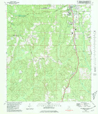
 1980 Bay Minette North1980 Print · USGSBay Minette and Stockton are captured during a period of steady growth in 1980, centered around the Louisville and Nashville rail line. Genealogists can locate family landmarks like Stockton Memorial Cem and Greater St John Ch.
 - 1980 Map of Bay Minette South, 1981 Print
 1980 Bay Minette South1981 Print · USGSBaldwin County in the early eighties shows the expansion of Bay Minette alongside the enduring rural character of its outlying communities. Researchers can trace local heritage through landmarks like Faulkner State Jr College, Whitehouse Forks, and the Johnson Cem.2 unique versions available
 - 1981 Map of Bay Minette
 1981 Bay Minette1981 Print · USGSThe Alabama-Florida borderlands come to life in the early 1980s as the river delta meets the growing coastal communities. Researchers can trace the Louisville and Nashville rail lines or locate historical points like Twenty-two Mile Bluff and the Blackwater River State Forest.2 unique versions available
 - 1986 Map of Bay Minette North
 1986 Bay Minette North1986 Print · USGSNorth Baldwin County in the mid-eighties shows a landscape of growing hubs and river-bound settlements. Researchers can trace family history through the Stockton Memorial Cem or locate the Armory and Stannard Cem near the SEABOARD tracks.
End of results
Showing maps 1-4 of 4
Top cities near Bay Minette
- Mobile historical maps
- Daphne historical maps
- Spanish Fort historical maps
- Loxley historical maps
- Stapleton historical maps
- Creola historical maps
See more
Top neighborhoods of Bay Minette
Frequently asked questions
- What are the different types of historical maps available for Bay Minette?
- What is the oldest map of Bay Minette?
- Where can I purchase historical maps of Bay Minette for my home or office?
- Where can I download high-res historical maps of Bay Minette?
- Are there historical topographic maps available for Bay Minette?
- Is there historical aerial imagery available for Bay Minette?
- Where are historical maps of Bay Minette sourced from?