1960s Maps of Locust Fork, Alabama
Explore 3 historic maps of Locust Fork from the 1960s. These maps offer a rare glimpse into what life looked like during the 1960s — showing old roads, neighborhoods, homes, and landmarks that have changed or disappeared over time.
Whether you're researching your family's past, planning a metal detecting trip, or studying how Locust Fork's landscape evolved across the 1960s, these high-resolution maps are a powerful tool for exploring the history of this region.
- Focus on a specific era: All maps on this page are from the 1960s, giving you a focused view of this time period.
- See what’s changed: Compare century-old streets, trails, and buildings to today's modern landscape using overlays and satellite layers.
- Research with precision: Use these maps for genealogy, historical research, land use analysis, or educational projects.
- View, download, or print: Maps are fully viewable online in high resolution, and can be downloaded or printed for your own records.
Start exploring Locust Fork's history through authentic maps from the 1960s. This is your window into the past.
Locust Fork, AL maps
(3)- 1960 Map of Remlap, 1963 Print
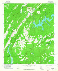 1960 Remlap1963 Print · USGSCentral Alabama's ridges and valleys are meticulously detailed in the early 1960s, showing the intersection of rural life and early industrial expansion. Trace family history at Pleasant Mount Ch or explore the geography of Remlap and Inland Reservoir.6 unique versions available
 - 1961 Map of Nectar, 1963 Print
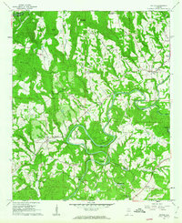 1961 Nectar1963 Print · USGSBlount County communities thrived along the winding Locust Fork in the early sixties. Genealogists and historians can trace family-named sites like McAnally Cove, the Covered Bridge, and rural landmarks from Wallstown to Nectar.3 unique versions available
 - 1961 Map of Trafford, 1963 Print
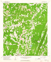 1961 Trafford1963 Print · USGSThe rural coal and rail corridors north of Birmingham are frozen in time during the early sixties. Genealogists and local historians can trace family locations through numerous sites like Bradford (Dixiana PO), Sterling Sch, and the Masseyline Cem.5 unique versions available
End of results
Showing maps 1-3 of 3
Top cities near Locust Fork
- Birmingham historical maps
- Trussville historical maps
- Cullman historical maps
- Center Point historical maps
- Gardendale historical maps
- Clay historical maps
See more
Frequently asked questions
- What are the different types of historical maps available for Locust Fork?
- What is the oldest map of Locust Fork?
- Where can I purchase historical maps of Locust Fork for my home or office?
- Where can I download high-res historical maps of Locust Fork?
- Are there historical topographic maps available for Locust Fork?
- Is there historical aerial imagery available for Locust Fork?
- Where are historical maps of Locust Fork sourced from?