1970s Maps of Locust Fork, Alabama
Explore 4 historic maps of Locust Fork from the 1970s. These maps offer a rare glimpse into what life looked like during the 1970s — showing old roads, neighborhoods, homes, and landmarks that have changed or disappeared over time.
Whether you're researching your family's past, planning a metal detecting trip, or studying how Locust Fork's landscape evolved across the 1970s, these high-resolution maps are a powerful tool for exploring the history of this region.
- Focus on a specific era: All maps on this page are from the 1970s, giving you a focused view of this time period.
- See what’s changed: Compare century-old streets, trails, and buildings to today's modern landscape using overlays and satellite layers.
- Research with precision: Use these maps for genealogy, historical research, land use analysis, or educational projects.
- View, download, or print: Maps are fully viewable online in high resolution, and can be downloaded or printed for your own records.
Start exploring Locust Fork's history through authentic maps from the 1970s. This is your window into the past.
Locust Fork, AL maps
(4)- 1975 Map of Nectar, 1977 Print
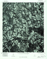 1975 Nectar1977 Print · USGSBlount County land use and river geography are captured in detail during the mid-seventies. Researchers can trace the sharp meanders of the Locust Fork and locate rural homesteads around Nectar, Locust, and Ville.
 - 1975 Map of Trafford, 1977 Print
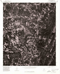 1975 Trafford1977 Print · USGSNorth-central Alabama comes into clear focus in the mid-seventies through this detailed orthophotograph. Genealogists and land researchers can trace the settlement of Trafford and the winding path of the Locus watercourse.
 - 1975 Map of Remlap, 1977 Print
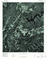 1975 Remlap1977 Print · USGSBlount County in the mid-seventies is captured in this detailed orthophoto, revealing the rural character of the Alabama landscape. Researchers can trace the sprawling reach of INLAND LAKE and find the small settlement of REMLAP along the western ridge.
 - 1975 Map of Cleveland, 1977 Print
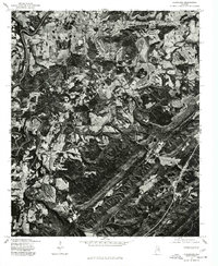 1975 Cleveland1977 Print · USGSMid-1970s Blount County comes into sharp focus in this aerial orthophotomap, showing the rural landscape around Cleveland as it appeared before modern development. Trace the winding Locust Fork and the settlement patterns near Allgood.
End of results
Showing maps 1-4 of 4
Top cities near Locust Fork
- Birmingham historical maps
- Trussville historical maps
- Cullman historical maps
- Center Point historical maps
- Gardendale historical maps
- Clay historical maps
See more
Frequently asked questions
- What are the different types of historical maps available for Locust Fork?
- What is the oldest map of Locust Fork?
- Where can I purchase historical maps of Locust Fork for my home or office?
- Where can I download high-res historical maps of Locust Fork?
- Are there historical topographic maps available for Locust Fork?
- Is there historical aerial imagery available for Locust Fork?
- Where are historical maps of Locust Fork sourced from?