1970s Maps of Snead, Alabama
Explore 3 historic maps of Snead from the 1970s. These maps offer a rare glimpse into what life looked like during the 1970s — showing old roads, neighborhoods, homes, and landmarks that have changed or disappeared over time.
Whether you're researching your family's past, planning a metal detecting trip, or studying how Snead's landscape evolved across the 1970s, these high-resolution maps are a powerful tool for exploring the history of this region.
- Focus on a specific era: All maps on this page are from the 1970s, giving you a focused view of this time period.
- See what’s changed: Compare century-old streets, trails, and buildings to today's modern landscape using overlays and satellite layers.
- Research with precision: Use these maps for genealogy, historical research, land use analysis, or educational projects.
- View, download, or print: Maps are fully viewable online in high resolution, and can be downloaded or printed for your own records.
Start exploring Snead's history through authentic maps from the 1970s. This is your window into the past.
Snead, AL maps
(3)- 1975 Map of Susan Moore, 1977 Print
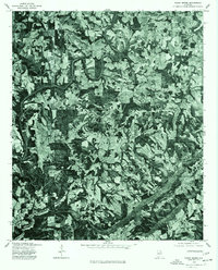 1975 Susan Moore1977 Print · USGSBlount County land patterns are captured in detail in the mid-1970s, showing the transition between family farms and woodland. Researchers can pinpoint specific homesteads and road networks around Susan Moore, Snead Crossroads, and Hendrix.2 unique versions available
 - 1975 Map of Brooksville, 1977 Print
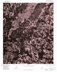 1975 Brooksville1977 Print · USGSBlount County comes into sharp focus during the mid-seventies in this detailed orthophotograph of the northern Alabama countryside. Local historians and land researchers can trace the specific field boundaries and rural road networks connecting Brooksville and Nixon Chapel.2 unique versions available
 - 1975 Map of Altoona, 1977 Print
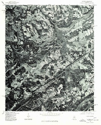 1975 Altoona1977 Print · USGSNorth Alabama's rural landscape comes into focus in the mid-1970s through this aerial orthophotomap of Etowah County. Researchers can trace the development of small communities like Altoona, Walnut Grove, and Snead against the backdrop of local timber and farm land.2 unique versions available
End of results
Showing maps 1-3 of 3
Top cities near Snead
- Albertville historical maps
- Rainbow City historical maps
- Boaz historical maps
- Guntersville historical maps
- Arab historical maps
- Oneonta historical maps
See more
Top neighborhoods of Snead
Frequently asked questions
- What are the different types of historical maps available for Snead?
- What is the oldest map of Snead?
- Where can I purchase historical maps of Snead for my home or office?
- Where can I download high-res historical maps of Snead?
- Are there historical topographic maps available for Snead?
- Is there historical aerial imagery available for Snead?
- Where are historical maps of Snead sourced from?