
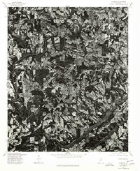
1975 Map of Susan Moore
USGS Topo · Published 1977About this map
Susan Moore serves as the central hub of this mid-1970s orthophotoquad, which uses aerial imagery to reveal the agricultural and forest patterns of this section of Blount County. Unlike a traditional topographic line map, this survey provides a direct photographic view of the land use in and around Snead Crossroads, showcasing a landscape of irregular field boundaries and dense woodland. To the southwest, the settlement of Hendrix is situated amidst a topography clearly defined by the winding paths of local watercourses. The imagery, produced in cooperation with the Soil Conservation Service, offers genealogists and local historians a clear look at the proximity of homesteads and farm buildings to the primary roads during a period of steady rural development in northern Alabama.
Find a feature on this map
3 named features on this map. Tap any name to fly to it.
Don’t see what you’re looking for? This feature index may not catch every label — zoom into the map to look around manually.
Map Details
Editions of this 1975 Susan Moore Map
2 editions found
Other maps of this area

1885 · Gadsden
USGS Topo · 1:125,000

1888 · Cullman
USGS Topo · 1:125,000

1888 · Gadsden
USGS Topo · 1:125,000

1889 · Springville
USGS Topo · 1:125,000

1889 · Birmingham
USGS Topo · 1:125,000

1892 · Cullman
USGS Topo · 1:125,000

1892 · Birmingham
USGS Topo · 1:125,000

1892 · Springville
USGS Topo · 1:125,000

1892 · Gadsden
USGS Topo · 1:125,000

1895 · Gadsden
USGS Topo · 1:125,000