1970s Maps of Coffeeville, Alabama
Explore 2 historic maps of Coffeeville from the 1970s. These maps offer a rare glimpse into what life looked like during the 1970s — showing old roads, neighborhoods, homes, and landmarks that have changed or disappeared over time.
Whether you're researching your family's past, planning a metal detecting trip, or studying how Coffeeville's landscape evolved across the 1970s, these high-resolution maps are a powerful tool for exploring the history of this region.
- Focus on a specific era: All maps on this page are from the 1970s, giving you a focused view of this time period.
- See what’s changed: Compare century-old streets, trails, and buildings to today's modern landscape using overlays and satellite layers.
- Research with precision: Use these maps for genealogy, historical research, land use analysis, or educational projects.
- View, download, or print: Maps are fully viewable online in high resolution, and can be downloaded or printed for your own records.
Start exploring Coffeeville's history through authentic maps from the 1970s. This is your window into the past.
Coffeeville, AL maps
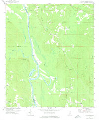
(2)- 1971 Map of Coffeeville, 1974 Print
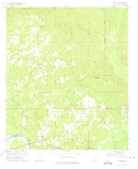 1971 Coffeeville1974 Print · USGSThe Tombigbee River country of Clarke County is shown here in the early 1970s, before modern infrastructure reshaped many rural Alabamian river towns. Researchers can trace family sites near Coffeeville, explore the crossroads at Center Point, and locate landmarks like Jones Chapel and the High Sch.2 unique versions available
 - 1972 Map of Tattlersville, 1975 Print
 1972 Tattlersville1975 Print · USGSThe Tombigbee River corridor in southwestern Alabama was defined by its water-bound commerce and quiet rural crossroads in the early 1970s. Genealogists can trace family names at Blount Landing and rural congregations at New Hope Ch or St Pauls Ch.2 unique versions available
End of results
Showing maps 1-2 of 2
Top cities near Coffeeville
- Jackson historical maps
- Gilbertown historical maps
- Millry historical maps
- Silas historical maps
- Toxey historical maps
Frequently asked questions
- What are the different types of historical maps available for Coffeeville?
- What is the oldest map of Coffeeville?
- Where can I purchase historical maps of Coffeeville for my home or office?
- Where can I download high-res historical maps of Coffeeville?
- Are there historical topographic maps available for Coffeeville?
- Is there historical aerial imagery available for Coffeeville?
- Where are historical maps of Coffeeville sourced from?