1970s Maps of Covington County, Alabama
Explore 26 historic maps of Covington County from the 1970s. These maps offer a rare glimpse into what life looked like during the 1970s — showing old roads, neighborhoods, homes, and landmarks that have changed or disappeared over time.
Whether you're researching your family's past, planning a metal detecting trip, or studying how Covington County's landscape evolved across the 1970s, these high-resolution maps are a powerful tool for exploring the history of this region.
- Focus on a specific era: All maps on this page are from the 1970s, giving you a focused view of this time period.
- See what’s changed: Compare century-old streets, trails, and buildings to today's modern landscape using overlays and satellite layers.
- Research with precision: Use these maps for genealogy, historical research, land use analysis, or educational projects.
- View, download, or print: Maps are fully viewable online in high resolution, and can be downloaded or printed for your own records.
Start exploring Covington County's history through authentic maps from the 1970s. This is your window into the past.
Covington County, AL maps
(26)- 1971 Map of Dixie, 1972 Print
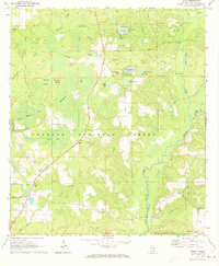
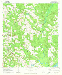
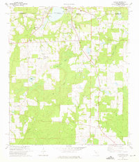
 1971 Dixie1972 Print · USGSIn the early seventies, the borderlands of Escambia and Covington counties remained a world of deep timber and quiet settlements. Genealogists can locate family landmarks like Mason Cem and Welfare Ch, or trace the path of the Old RR Grade through the Conecuh National Forest.3 unique versions available
 - 1971 Map of Bradley, 1972 Print
 1971 Bradley1972 Print · USGSCoastal plain timberlands and river bottoms define the Bradley area in the early seventies, at the crossroads of the Escambia Co and Covington Co line. Genealogists and local historians can trace the Old Railroad Grade or locate family sites at Old Bradley Cem and Union Hill Ch.2 unique versions available
 - 1971 Map of Brooks, 1972 Print
 1971 Brooks1972 Print · USGSConecuh and Covington counties come together in the early 1970s along the winding Sepulga River and the rural communities of South Alabama. Researchers can locate family landmarks like New Home Ch, the community of Cohassett, and the Louisville and Nashville rail line.2 unique versions available
 - 1971 Map of Carolina, 1972 Print
 1971 Carolina1972 Print · USGSIn the early seventies, the rural landscape of Covington County was defined by its timberlands and small crossroads communities. Genealogists and historians can trace family locations near Carolina and Pleasant Home, or locate the Shady Hill Cem and Shady Hill Ch.2 unique versions available
 - 1971 Map of Libertyville, 1973 Print
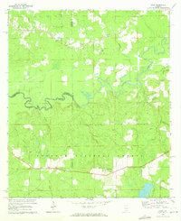
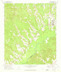
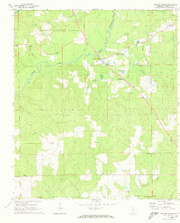
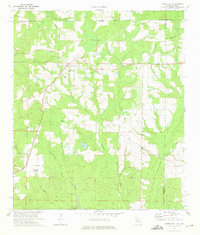
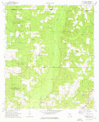
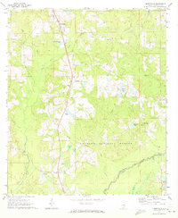 1971 Libertyville1973 Print · USGSCovington County is seen here in the early 1970s as a quiet expanse of timberland and small crossroads communities bordering the national forest. Researchers can locate family-named landmarks and rural congregations like Stanley, Judson Ch, and the Yellow River Lookout Tower.
 - 1971 Map of Dozier, 1973 Print
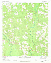
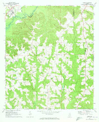 1971 Dozier1973 Print · USGSDozier and the surrounding Covington-Crenshaw county line are captured here in the early seventies, centered on the Conecuh River valley. Researchers can trace the Central of Georgia rail corridor and locate family sites like Rose Hill Cem and Pleasant Call Ch.
 - 1971 Map of Industry, 1973 Print
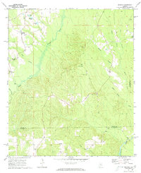 1971 Industry1973 Print · USGSSoutheastern Butler County was a network of rural hamlets and country churches in the early 1970s. Researchers can locate family landmarks like Oaky Streak, Industry, and Consolation Ch along the winding banks of Pigeon Creek.
 - 1971 Map of Onycha, 1973 Print
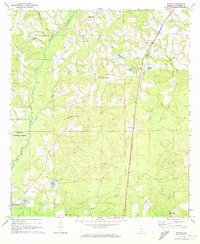 1971 Onycha1973 Print · USGSSouthern Covington County comes alive in this early 1970s survey of rural Alabama settlements and family landmarks. Researchers can trace the Louisville and Nashville line past Onycha or locate country churches like New Hope Ch.
 - 1971 Map of Wing, 1973 Print
 1971 Wing1973 Print · USGSCovington County was a landscape of timber and quiet forest settlements in the early 1970s. Trace the rural crossroads of Falco and Wing, or locate family landmarks like Mt Hermon Ch and Union Ch Cem near the winding Yellow River.2 unique versions available
 - 1971 Map of Brantley, 1973 Print
 1971 Brantley1973 Print · USGSCrenshaw and Covington counties come together at the Conecuh River in the early 1970s, as the Central of Georgia rail line links the timber and farm lands. Trace family roots at Mt Olive Ch Cem, Sasser Ch Cem, and the rural community of Theba.
 - 1971 Map of River Falls, 1973 Print
 1971 River Falls1973 Print · USGSThe Conecuh River valley in the early seventies shows the rural landscape of Covington County as it balanced industry and tradition. Genealogists can trace family roots through numerous sites like Presley Chapel, Cedar Grove Ch, and Bethlehem Cem.2 unique versions available
 - 1971 Map of Mc Kenzie, 1973 Print
 1971 Mc Kenzie1973 Print · USGSButler County and the surrounding tri-county borderlands appear here in the early seventies, centered on the railroad town of Mc Kenzie. Genealogists can trace family locations through sites like South Butler Academy, Riley Cem, and Sweet Home Ch.2 unique versions available
 - 1971 Map of Andalusia, 1973 Print
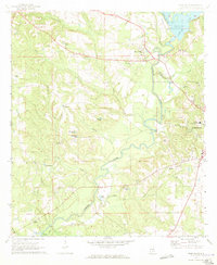
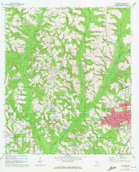
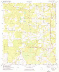
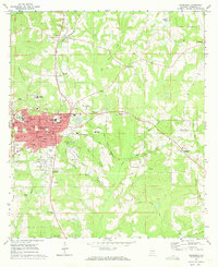 1971 Andalusia1973 Print · USGSCovington County in the early seventies centers on the bustling rail junction and academic institutions of Andalusia. Local historians can trace the paths of the Central of Georgia railroad or locate family sites at Bethany Ch, Magnolia Cem, and the Montezuma Academy.2 unique versions available
 - 1971 Map of Gantt, 1973 Print
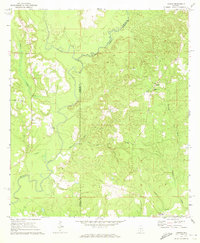
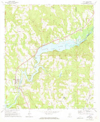 1971 Gantt1973 Print · USGSCovington County communities surround the impounded waters of the Conecuh River in the early seventies. Genealogists and historians can trace family locations near Gantt Lake and find rural landmarks like Zion Chapel Ch, Dunns Bridge, and the community of Searight.2 unique versions available
 - 1971 Map of Florala, 1973 Print
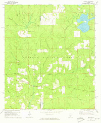
 1971 Florala1973 Print · USGSThe Alabama-Florida border comes alive in the early seventies, centered on the lakeside community of Florala and neighboring Lockhart. Genealogists and historians can trace local infrastructure through the Louisville and Nashville Railroad and smaller hubs like Johnsons Quarters.2 unique versions available
 - 1971 Map of Leon, 1973 Print
 1971 Leon1973 Print · USGSCrenshaw County in the early seventies reveals a landscape of dispersed rural settlements and active creek-side industry. Genealogists and local historians can trace old homesteads and landmarks like Merrill Mill, Zion Ch Cem, and the community of Leon.
 - 1971 Map of Red Level, 1973 Print
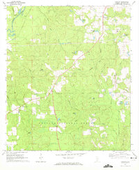
 1971 Red Level1973 Print · USGSCovington County in the early seventies is centered here on the town of Red Level as the Louisville and Nashville railroad winds through the pines. Researchers can trace family ties at Fairmount Cem, locate the site of Gunter Mill, or explore the many creek-side churches.2 unique versions available
 - 1971 Map of Watkins Bridge, 1973 Print
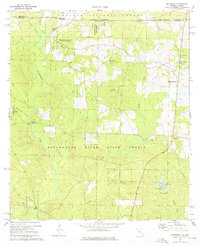
 1971 Watkins Bridge1973 Print · USGSSouthern Covington County is captured in the early seventies, showing a landscape of timber stands and creek-side settlements. Genealogists can locate family landmarks like Shiloh Cem, Huckaville, and the rural community at Damascus.
 - 1971 Map of Opp West, 1973 Print
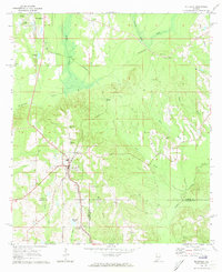
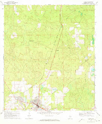
 1971 Opp West1973 Print · USGSCovington County settlement expanded west of the railroad in the early seventies, centered on the growing town of Opp. Researchers can trace local heritage through landmarks like Douglas MacArthur State Tech Inst, Gardner Chapel, and the Henderson Cem.2 unique versions available
 - 1971 Map of Loango, 1973 Print
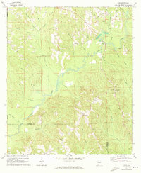
 1971 Loango1973 Print · USGSCovington and Conecuh counties in the early seventies reveal a landscape of river-bottom lands and small rural outposts. Researchers can trace family history at Loango, Mt Pilgrim Ch, and Darwin Cem along the winding Pigeon Creek.2 unique versions available
 - 1973 Map of Paxton, 1975 Print
 1973 Paxton1975 Print · USGSThe Florida-Alabama borderlands come to life in the early seventies, centered on the rail-side commerce of Paxton and Florala. Local historians can locate specific rural landmarks like St Marks Ch, the Childrens Home, and the Louisville and Nashville rail corridor.3 unique versions available
 - 1973 Map of Laurel Hill, 1975 Print
 1973 Laurel Hill1975 Print · USGSLaurel Hill and the surrounding Okaloosa County pinelands are captured here in the early seventies as the railroad still anchored the local economy. Researchers can trace family roots at Travelers Rest Cemetery, Mt Zion Church, and the settlement of Svea.2 unique versions available
 - 1973 Map of Gaskin, 1976 Print
 1973 Gaskin1976 Print · USGSThe Florida-Alabama border in the 1970s is characterized by its creek systems and small rural outposts. Researchers can trace land use through features like the Natural Bridge, the Gaskin settlement, and several remote cemeteries scattered near Big Swamp.3 unique versions available
 - 1973 Map of Blackman, 1976 Print
 1973 Blackman1976 Print · USGSUpper Okaloosa County is captured in the early 1970s as a landscape of timberlands and quiet crossroads settlements. You can trace family history at Red Oak Cem or locate the old Sand Hill Lookout Tower and Olive Branch Ch.3 unique versions available
 - 1973 Map of Oak Grove, 1976 Print
 1973 Oak Grove1976 Print · USGSThe Florida-Alabama borderlands come to life in this early 1970s survey of the Yellow River valley and its surrounding timberlands. Researchers can trace rural heritage through sites like Old Ebenezer Ch, the Louisville and Nashville rail line, and family cemeteries like Peaden Cem.2 unique versions available
Showing maps 1-25 of 26
Top cities of Covington County
- Andalusia historical maps
- Opp historical maps
- Florala historical maps
- Babbie historical maps
- River Falls historical maps
- Lockhart historical maps
See more
Frequently asked questions
- What are the different types of historical maps available for Covington County?
- What is the oldest map of Covington County?
- Where can I purchase historical maps of Covington County for my home or office?
- Where can I download high-res historical maps of Covington County?
- Are there historical topographic maps available for Covington County?
- Is there historical aerial imagery available for Covington County?
- Where are historical maps of Covington County sourced from?