1960s Maps of Abbeville, Alabama
Explore 2 historic maps of Abbeville from the 1960s. These maps offer a rare glimpse into what life looked like during the 1960s — showing old roads, neighborhoods, homes, and landmarks that have changed or disappeared over time.
Whether you're researching your family's past, planning a metal detecting trip, or studying how Abbeville's landscape evolved across the 1960s, these high-resolution maps are a powerful tool for exploring the history of this region.
- Focus on a specific era: All maps on this page are from the 1960s, giving you a focused view of this time period.
- See what’s changed: Compare century-old streets, trails, and buildings to today's modern landscape using overlays and satellite layers.
- Research with precision: Use these maps for genealogy, historical research, land use analysis, or educational projects.
- View, download, or print: Maps are fully viewable online in high resolution, and can be downloaded or printed for your own records.
Start exploring Abbeville's history through authentic maps from the 1960s. This is your window into the past.
Abbeville, AL maps
(2)- 1969 Map of Abbeville West
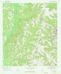 1969 Abbeville West1969 Print · USGSHenry County's rural character is preserved here in the late sixties as the town of Abbeville expands toward the East Fork Choctawhatchee River. Researchers can locate several family burial grounds like Hutto Cem and landmarks such as Murphy Station and the local Drive-in Theater.2 unique versions available
 - 1969 Map of Abbeville East, 1971 Print
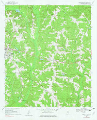 1969 Abbeville East1971 Print · USGSEastern Henry County in the late sixties shows the rural character of the Wiregrass region as it centers around the town of Abbeville. Genealogists can trace family names through landmarks like Tillis Pond, Wills Crossroads, and rural cemeteries like Ebenezer Cem.2 unique versions available
End of results
Showing maps 1-2 of 2
Top cities near Abbeville
- Eufaula historical maps
- Headland historical maps
- Fort Gaines historical maps
- Newville historical maps
- Bakerhill historical maps
- Haleburg historical maps
Top neighborhoods of Abbeville
Frequently asked questions
- What are the different types of historical maps available for Abbeville?
- What is the oldest map of Abbeville?
- Where can I purchase historical maps of Abbeville for my home or office?
- Where can I download high-res historical maps of Abbeville?
- Are there historical topographic maps available for Abbeville?
- Is there historical aerial imagery available for Abbeville?
- Where are historical maps of Abbeville sourced from?